Picture 1 of 11


Gallery
Picture 1 of 11


Have one to sell?
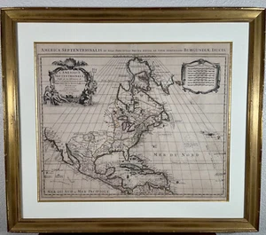
1730s Guillaume Delisle Covens & Mortier North America Map Hand Colored 18th C.

US $1,395.00
or Best Offer
as low as $86.37/mo with
Condition:
- Buy It Now1730s Guillaume Delisle Covens & Mortier North America Map Hand Colored 18th C.
Oops! Looks like we're having trouble connecting to our server.
Refresh your browser window to try again.
Shipping:
US $59.95 UPS Ground.
Located in: Benicia, California, United States
Delivery:
Estimated between Wed, Jul 23 and Tue, Jul 29 to 94104
Returns:
14 days returns. Buyer pays for return shipping. If you use an eBay shipping label, it will be deducted from your refund amount.
Payments:
.
As low as $86.37/mo with Klarna.
*No Interest if paid in full in 6 months on $149+. See terms and apply now- for PayPal Credit, opens in a new window or tab
Earn up to 5x points when you use your eBay Mastercard®. Learn moreabout earning points with eBay Mastercard
Shop with confidence
Seller assumes all responsibility for this listing.
eBay item number:126654187232
Item specifics
- Date Range
- 1700-1799
- Type
- Physical Map
- Mexican State
- Baja California, Baja California Sur, Yucatán
- Printing Technique
- Copper Plate
- Format
- Sheet Map
- US State
- AL, FL, GA, MS, NC, SC, AR, IA, KS, LA, MO, NE, AZ, CA, CO, NM, NV, UT, California, VA, WV, KY, TN
- Year
- 1730
- Cartographer/Publisher
- Guillaume De L'Isle
- Original/Reproduction
- Antique Original
- Country/Region
- United States of America
Item description from the seller

Seller feedback (732)
- i***f (1811)- Feedback left by buyer.Past monthVerified purchaseSo incredibly beautiful! Exactly as described. This was wrapped up very well, shipped quickly, and arrived to me in perfect shape. I feel so lucky to have it. Excellent seller!
- 7***s (58)- Feedback left by buyer.Past monthVerified purchaseItem arrived quickly. Packaged extremely well. As described. Great value. Thank you so much!
- r***r (799)- Feedback left by buyer.Past 6 monthsVerified purchasePositive ebay experience, super responsive seller. Item as represented and well packed!
More to explore :
- Manuscript/Hand drawn County Map Antique North America Sheet Maps,
- Manuscript/Hand drawn Antique North America Sheet Maps,
- Manuscript/Hand drawn Antique North America County Maps,
- Antique North America Maps & Atlases,
- Antique North America Michigan Maps,
- North Carolina Antique North America Maps & Atlases,
- Antique North America Political Maps,
- Antique North America Topographical Maps,
- Antique North America Railroad Maps,
- Antique North America Atlas Maps
Seller feedback (732)
- i***f (1811)- Feedback left by buyer.Past monthVerified purchaseSo incredibly beautiful! Exactly as described. This was wrapped up very well, shipped quickly, and arrived to me in perfect shape. I feel so lucky to have it. Excellent seller!
- 7***s (58)- Feedback left by buyer.Past monthVerified purchaseItem arrived quickly. Packaged extremely well. As described. Great value. Thank you so much!
- r***r (799)- Feedback left by buyer.Past 6 monthsVerified purchasePositive ebay experience, super responsive seller. Item as represented and well packed!