


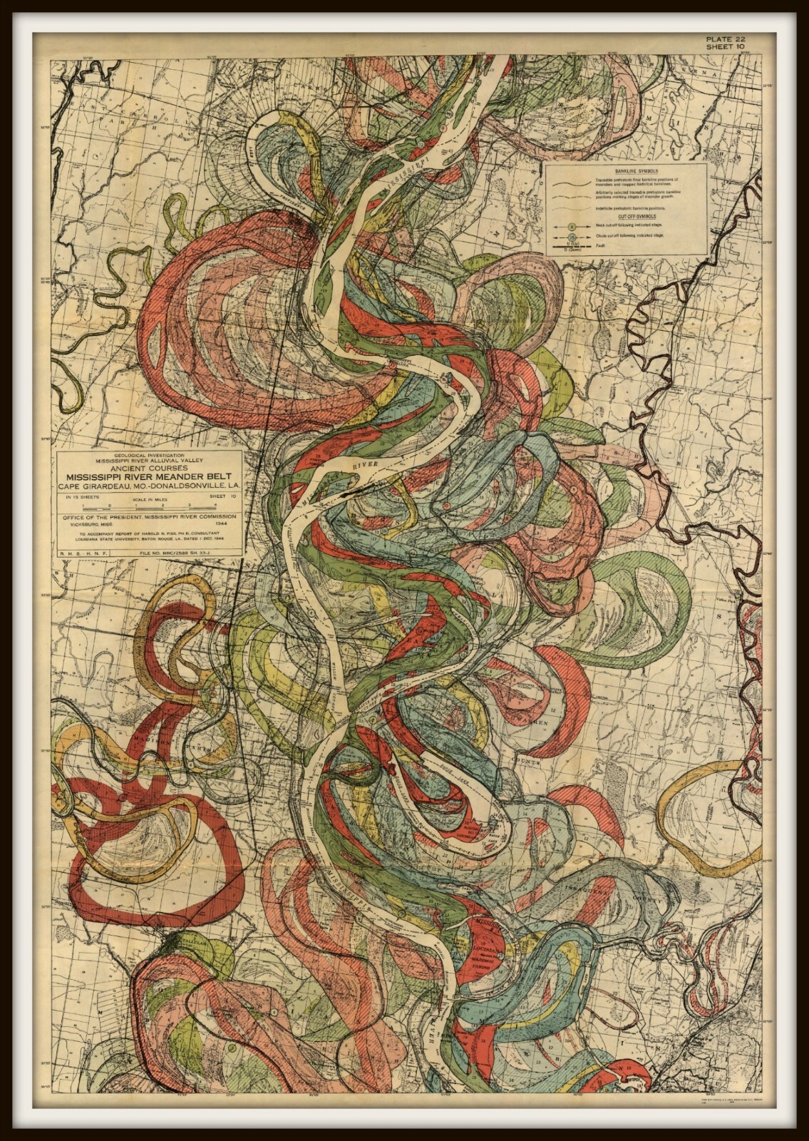


Mississippi River Map, Louisiana River, Harold Fisk Map, Page 22 Sheet 10

US $20.35
Condition:
New
A brand-new, unused, unopened, undamaged item in its original packaging (where packaging is applicable). Packaging should be the same as what is found in a retail store, unless the item is handmade or was packaged by the manufacturer in non-retail packaging, such as an unprinted box or plastic bag. See the seller's listing for full details.
Please select a Size
Please select a Finish
More than 10 available
- Buy It NowMississippi River Map, Louisiana River, Harold Fisk Map, Page 22 Sheet 10
Oops! Looks like we're having trouble connecting to our server.
Refresh your browser window to try again.
Shipping:
Free USPS First Class®.
Located in: Hyattsville, Maryland, United States
Delivery:
Estimated between Thu, Jul 3 and Wed, Jul 9 to 94104
Returns:
30 days returns. Seller pays for return shipping.
Payments:
Special financing available. See terms and apply now- for PayPal Credit, opens in a new window or tab
Earn up to 5x points when you use your eBay Mastercard®. Learn moreabout earning points with eBay Mastercard
Shop with confidence
Seller assumes all responsibility for this listing.
eBay item number:133320918008
Item specifics
- Condition
- Artist
- Harold Fisk, Cartographer & Geologist
- Model
- Mississippi River, River Meander
- Country/Region of Manufacture
- United States
- Style
- Vintage
- Material
- Museum Quality Archival Canvas & Papers
- Original/Reproduction
- Reproduction
- Date of Creation
- 1900-1949
- Signed?
- Unsigned
- Mississippi Meander Belt, Meander Belt
- River Mississippi, River Belt
- Baton Rouge, Mississippi River
- Meander Belt, Harold Fisk Map, Page 22, Sheet 10
- Type
- Giclee & Iris Print
- River Meander, Mississippi Meander Belt
- Baton Rouge River, Harold Fisk Maps
- Mississippi River Map, Louisiana River
- Harold Fisk Map, Page 22 Sheet 10
- Features
- 100% Musuem Quality Archival Canvas & Papers, Gallery Wrapped Canvas Ready to Hang or You Frame, Guaranteed to Not Fade or Crack for 100 Years
- Mississippi River Meander Belt
- Mississippi Mississippi, Fisk Maps
- Geology Maps
- Army Corps of Engineers
- Color
- Multi-Color
- MPN
- Mississippi River Meander Belt
- Subject
- Maps
- Brand
- ThePreciousPast
Item description from the seller

Seller feedback (284)
- *****- Feedback left by buyer.Past monthVerified purchaseGreat seller and fast shipping! Item packaged and secured nicely.
- *****- Feedback left by buyer.Past yearVerified purchaseGreat transaction, items as described, packaged well and very fast shipping. Have purchased from this seller in the past and will do so in the future.
- *****- Feedback left by buyer.Past 6 monthsVerified purchaseSo carefully packaged, love this seller!
This is a private listing and your identity will not be disclosed to anyone except the seller.
Seller feedback (284)
- *****- Feedback left by buyer.Past monthVerified purchaseGreat seller and fast shipping! Item packaged and secured nicely.
- *****- Feedback left by buyer.Past yearVerified purchaseGreat transaction, items as described, packaged well and very fast shipping. Have purchased from this seller in the past and will do so in the future.
- *****- Feedback left by buyer.Past 6 monthsVerified purchaseSo carefully packaged, love this seller!