
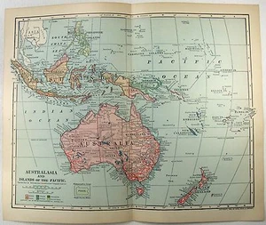
Original 1902 Dated Map of Australasia & the Pacific Islands by Dodd Mead
US $18.00US $18.00
Thu, May 15, 06:13 PMThu, May 15, 06:13 PM
Picture 1 of 3


Gallery
Picture 1 of 3


Have one to sell?
Original 1902 Dated Map of Australasia & the Pacific Islands by Dodd Mead

US $18.00
Condition:
“Minor edge wear, a bit of age toning and one center fold, otherwise this attractive vintage map is ”... Read moreabout condition
Oops! Looks like we're having trouble connecting to our server.
Refresh your browser window to try again.
Shipping:
Free 2-4 day delivery
Get it between Tue, Jul 22 and Thu, Jul 24 to 94104.
Located in: Sayville, New York, United States
Returns:
30 days returns. Seller pays for return shipping.
Payments:
Special financing available. See terms and apply now- for PayPal Credit, opens in a new window or tab
Earn up to 5x points when you use your eBay Mastercard®. Learn moreabout earning points with eBay Mastercard
Shop with confidence
Seller assumes all responsibility for this listing.
eBay item number:146511183086
Item specifics
- Seller Notes
- Publication Year
- 1902
- Date Range
- 1900-1909
- Type
- Map
- Printing Technique
- Lithography
- Format
- Atlas Map
- Year
- 1902
- Original/Reproduction
- Original
- Cartographer/Publisher
- Dodd Mead & Company
- Country/Region
- Australia, Fiji, New Caledonia, New Zealand, Vanuatu
- Maker
- Dodd Mead & Company
- Original Reproduction Reprint
- Original
Item description from the seller

Popular categories from this store
Seller feedback (6,283)
This item (1)
All items (6,283)
- a***r (643)- Feedback left by buyer.Past 6 monthsVerified purchaseJust as described. Well packaged.
- 3***b (31)- Feedback left by buyer.Past 6 monthsVerified purchaseExcellent 5 Star Seller, great vintage condition as listed with great price and FREE shipping which was greatly appreciated, arrived as listed. Requested it be shipped to my brother in another city and arrived as requested, Wonderful experience. Thank you ever so much!!
- b***a (1433)- Feedback left by buyer.Past 6 monthsVerified purchaseThis map was a delight to receive and it was packaged so well and received fast! It was just as described and the price was great! Thank you I LOVE it!!!!
- j***o (78)- Feedback left by buyer.Past 6 monthsVerified purchaseGreat description. Excellent packaging. Reasonable shipping. Happy with this purchase. Great value.Eastern USA - Original 1909 Physical Map by John Bartholomew. Antique (#145896769371)
More to explore :
- Rhode Island Antique Original Antique North American Maps & Atlases 1900-1909 Date Range,
- Rhode Island Antique Original Antique North American Maps & Atlases 1910-1919 Date Range,
- Rhode Island Antique Original Antique North American Maps & Atlases 1950-1959 Date Range,
- Antique Original Rhode Island 1800-1899 Date Range Antique North America Maps & Atlases,
- Prince Edward Island Antique Original Antique North American Maps & Atlases 1800-1899 Date Range,
- Rhode Island 1800-1899 Date Range Antique North America Railroad Maps,
- Antique Original 1700-1799 Date Range Antique County Maps,
- Antique Original 1920-1929 Date Range Antique River Maps,
- Antique Original 1960-1969 Date Range Antique School Maps,
- Antique Original 1600-1699 Date Range Antique City Maps
Popular categories from this store
Seller feedback (6,283)
This item (1)
All items (6,283)
- a***r (643)- Feedback left by buyer.Past 6 monthsVerified purchaseJust as described. Well packaged.
- 3***b (31)- Feedback left by buyer.Past 6 monthsVerified purchaseExcellent 5 Star Seller, great vintage condition as listed with great price and FREE shipping which was greatly appreciated, arrived as listed. Requested it be shipped to my brother in another city and arrived as requested, Wonderful experience. Thank you ever so much!!
- b***a (1433)- Feedback left by buyer.Past 6 monthsVerified purchaseThis map was a delight to receive and it was packaged so well and received fast! It was just as described and the price was great! Thank you I LOVE it!!!!
- j***o (78)- Feedback left by buyer.Past 6 monthsVerified purchaseGreat description. Excellent packaging. Reasonable shipping. Happy with this purchase. Great value.Eastern USA - Original 1909 Physical Map by John Bartholomew. Antique (#145896769371)