
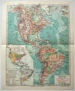


Original Physical & Economic Map of the Americas in 1910 by Meyers. German

US $17.00
Condition:
“Some age toning, a touch of wear and one center fold, otherwise this rare map is in very good ”... Read moreabout condition
- Buy It NowOriginal Physical & Economic Map of the Americas in 1910 by Meyers. German
Oops! Looks like we're having trouble connecting to our server.
Refresh your browser window to try again.
Shipping:
Free 2-4 day delivery
Get it between Sat, Jun 14 and Tue, Jun 17 to 94104.
Located in: Sayville, New York, United States
Returns:
30 days returns. Seller pays for return shipping.
Payments:
Earn up to 5x points when you use your eBay Mastercard®. Learn moreabout earning points with eBay Mastercard
Shop with confidence
Seller assumes all responsibility for this listing.
eBay item number:146518450224
Item specifics
- Seller Notes
- Date Range
- 1910-1919
- Type
- Physical Map
- Format
- Atlas Map
- Printing Technique
- Lithography
- Mexican State
- Aguascalientes, Baja California, Baja California Sur, Campeche, Chiapas, Chihuahua, Coahuila, Colima, Durango, Guanajuato, Guerrero, Hidalgo, Jalisco, Michoacán, Morelos, Nayarit, Nuevo León, Oaxaca, Puebla, Querétaro, Quintana Roo, San Luis Potosí, Sinaloa, Sonora, Tabasco, Tamaulipas, Tlaxcala, Veracruz, Yucatán, Zacatecas
- Year
- 1910
- Canadian Province
- Alberta, British Columbia, Manitoba, New Brunswick, Newfoundland & Labrador, Northwest Territories, Nova Scotia, Nunavut, Ontario, Prince Edward Island, Quebec, Saskatchewan, Yukon
- Original/Reproduction
- Antique Original
- Cartographer/Publisher
- Dodd Mead & Company
- Country/Region
- United States of America
Item description from the seller

Popular categories from this store
Seller feedback (6,273)
- b***a (1416)- Feedback left by buyer.Past monthVerified purchaseThis map was a delight to receive and it was packaged so well and received fast! It was just as described and the price was great! Thank you I LOVE it!!!!
- j***o (77)- Feedback left by buyer.Past 6 monthsVerified purchaseGreat description. Excellent packaging. Reasonable shipping. Happy with this purchase. Great value.Eastern USA - Original 1909 Physical Map by John Bartholomew. Antique (#145896769371)
- 7***l (1139)- Feedback left by buyer.Past 6 monthsVerified purchaseshipped quickly, well packed, as described, easy transaction
More to explore :
- 1910-1919 Date Range Antique North America Physical Maps,
- Vintage Original Antique North America Physical Maps,
- Antique Original Antique South America Physical Maps,
- Antique Original Antique North America Physical Maps,
- Physical Map Vintage Original Antique North America Atlas Maps,
- Physical Map Antique North America Folding Maps,
- 1910-1919 Date Range Antique Physical Maps,
- Physical Map Antique North America Atlas,
- Physical Map Vintage Original Antique Atlas Maps,
- Physical Map Sheet Map 1910-1919 Date Range Antique Maps, Atlases & Globes
Popular categories from this store
Seller feedback (6,273)
- b***a (1416)- Feedback left by buyer.Past monthVerified purchaseThis map was a delight to receive and it was packaged so well and received fast! It was just as described and the price was great! Thank you I LOVE it!!!!
- j***o (77)- Feedback left by buyer.Past 6 monthsVerified purchaseGreat description. Excellent packaging. Reasonable shipping. Happy with this purchase. Great value.Eastern USA - Original 1909 Physical Map by John Bartholomew. Antique (#145896769371)
- 7***l (1139)- Feedback left by buyer.Past 6 monthsVerified purchaseshipped quickly, well packed, as described, easy transaction