
1852 Map of The United States Mitchell's Territory Indian Utah Washington
US $49.50US $49.50
Sun, Apr 27, 08:20 PMSun, Apr 27, 08:20 PM


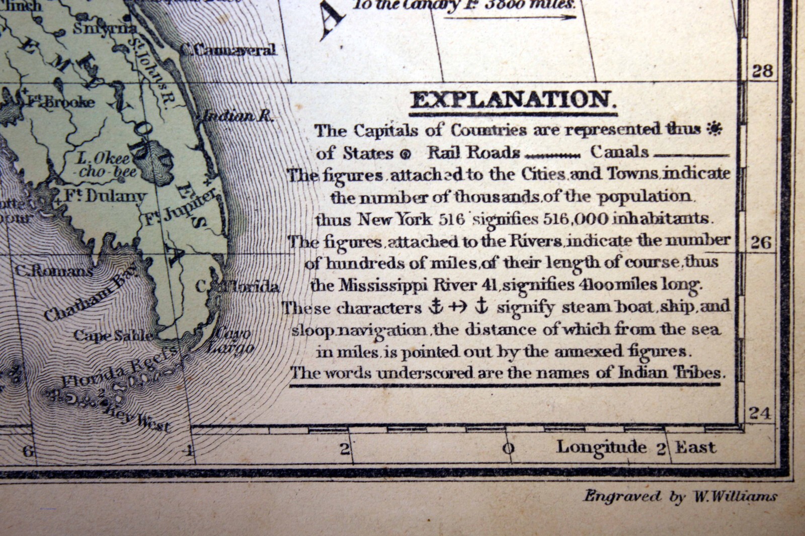


1852 Map of The United States Mitchell's Territory Indian Utah Washington

US $49.50
or Best Offer
Condition:
“Very good condition (see photos)..”
Oops! Looks like we're having trouble connecting to our server.
Refresh your browser window to try again.
Shipping:
US $6.55 USPS First Class®.
Located in: Corunna, Michigan, United States
Delivery:
Estimated between Thu, Jul 3 and Wed, Jul 9 to 94104
Returns:
30 days returns. Buyer pays for return shipping. If you use an eBay shipping label, it will be deducted from your refund amount.
Payments:
.
Special financing available. See terms and apply now- for PayPal Credit, opens in a new window or tab
Earn up to 5x points when you use your eBay Mastercard®. Learn moreabout earning points with eBay Mastercard
Shop with confidence
Seller assumes all responsibility for this listing.
eBay item number:146538202857
Item specifics
- Seller Notes
- “Very good condition (see photos)..”
- Date Range
- 1800-1899
- Format
- Atlas Map
- Printing Technique
- Copper Plate
- Year
- 1852
- Original/Reproduction
- Antique Original
- Cartographer/Publisher
- Samuel Augustus Mitchell
- Country/Region
- United States of America
- Suitable for framing
- 11½ x 18¼ inches
Item description from the seller

Seller feedback (10,067)
This item (1)
All items (10,067)
- d***d (425)- Feedback left by buyer.Past monthVerified purchaseQuick shipping, exceptionally packed, item as described, and we'll worth the value. Excellent seller! Highly recommend. Shalom.
- n***c (301)- Feedback left by buyer.Past yearVerified purchaseGREAT transaction!! Pleased with all aspects of this sale. Very accurate listing. Was a little surprised at the shipping cost ($6.25) but then learned the seller shipped in crush-proof tubes. As I was buying a map from 1904 as a Christmas gift for one of our children, it was awesome to see it arrive in the same great shape it shipped in! I appreciated the value the extra shipping cost provided to ensure the map arrived safely, with no fold creases!! Thanks for making our Christmas Merry!!1904 Outline Map of Du Page County Illinois (#145949997683)
- 9***w (173)- Feedback left by buyer.Past 6 monthsVerified purchaseGreat communication with seller. Map is wonderful condition. Packaged in a sturdy tube. Thank you. Recommend seller! Slow shipping was USPS fault, not the seller.1915 Map of The World on Mercator's Projection Color 17" x 28" (#365089751959)
More to explore :
- United States of America Utah Antique North America Maps & Atlases,
- Washington United States of America Washington Antique North America Maps & Atlases,
- United States of America Utah Antique North America Sheet Maps,
- United States of America Utah Antique North America Atlas Maps,
- United States of America Utah Antique North America Topographical Maps,
- United States of America Washington Antique North America County Maps,
- Washington United States of America Virginia Antique North America Maps & Atlases,
- Washington United States of America ID, OR, WA Antique North American Maps & Atlases,
- United States of America River Map Antique North America Sheet Maps,
- United States of America Geological Map Antique North America Atlas Maps
Seller feedback (10,067)
This item (1)
All items (10,067)
- d***d (425)- Feedback left by buyer.Past monthVerified purchaseQuick shipping, exceptionally packed, item as described, and we'll worth the value. Excellent seller! Highly recommend. Shalom.
- n***c (301)- Feedback left by buyer.Past yearVerified purchaseGREAT transaction!! Pleased with all aspects of this sale. Very accurate listing. Was a little surprised at the shipping cost ($6.25) but then learned the seller shipped in crush-proof tubes. As I was buying a map from 1904 as a Christmas gift for one of our children, it was awesome to see it arrive in the same great shape it shipped in! I appreciated the value the extra shipping cost provided to ensure the map arrived safely, with no fold creases!! Thanks for making our Christmas Merry!!1904 Outline Map of Du Page County Illinois (#145949997683)
- 9***w (173)- Feedback left by buyer.Past 6 monthsVerified purchaseGreat communication with seller. Map is wonderful condition. Packaged in a sturdy tube. Thank you. Recommend seller! Slow shipping was USPS fault, not the seller.1915 Map of The World on Mercator's Projection Color 17" x 28" (#365089751959)