
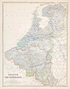
Belgium & The Netherlands map by Keith Johnston map Royal Atlas original 1869
GBP 130.00GBP 130.00
Tue, Jun 10, 03:29 AMTue, Jun 10, 03:29 AM
Picture 1 of 5


Gallery
Picture 1 of 5


Have one to sell?
Belgium & The Netherlands map by Keith Johnston map Royal Atlas original 1869
GBP 130.00
ApproximatelyUS $174.41
Condition:
“Excellent clean condition - Please see description below”
Oops! Looks like we're having trouble connecting to our server.
Refresh your browser window to try again.
Shipping:
GBP 17.95 (approx US $24.08) Standard Int'l Postage.
International shipment of items may be subject to customs processing and additional charges.
Located in: Bourne End, United Kingdom
Delivery:
Estimated between Fri, Jul 25 and Tue, Aug 5 to 91768
Returns:
Seller does not accept returns.
Payments:
Earn up to 5x points when you use your eBay Mastercard®. Learn moreabout earning points with eBay Mastercard
Shop with confidence
Seller assumes all responsibility for this listing.
eBay item number:167441664372
Item specifics
- Seller Notes
- “Excellent clean condition - Please see description below”
- Date Range
- 1800-1899
- Antique
- Yes
- Format
- Atlas
- Year
- 1869
- Era
- 1800s
- Cartographer/Publisher
- Keith Johnston
- Original/Reproduction
- Antique Original
- Country/Region
- Belgium, Netherlands
Item description from the seller
Seller Feedback
No feedback yet
More to explore :
- Belgium City Map Antique Europe Atlas Maps,
- Belgium County Map Antique Europe Atlas Maps,
- Belgium Political Map Antique Europe Atlas Maps,
- Belgium Antique Original Antique Europe Atlas Maps,
- Netherlands Antique Original Antique Europe Atlas Maps,
- Keith Johnston Antique Maps, Atlases & Globes,
- Antique Original Nautical Map Antique Atlas Maps,
- Antique Original River Map Antique Atlas Maps,
- Antique Original Topographical Map Antique Atlas Maps,
- Physical Map Vintage Original Antique Atlas Maps