
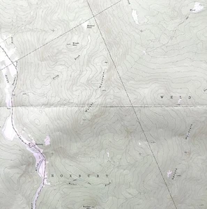
Map Roxbury Maine 1969 Topographic Geo Survey 1:24000 27 x 22" TOPO6
US $52.49US $52.49
Fri, May 23, 06:08 AMFri, May 23, 06:08 AM
Picture 1 of 3


Gallery
Picture 1 of 3


Have one to sell?
Map Roxbury Maine 1969 Topographic Geo Survey 1:24000 27 x 22" TOPO6
US $52.49
or Best Offer
Condition:
Oops! Looks like we're having trouble connecting to our server.
Refresh your browser window to try again.
Shipping:
US $20.20 USPS Priority Mail®.
Located in: Cambridge, Maine, United States
Delivery:
Estimated between Wed, Jul 23 and Tue, Jul 29 to 94104
Returns:
30 days returns. Seller pays for return shipping.
Payments:
.
Special financing available. See terms and apply now- for PayPal Credit, opens in a new window or tab
Earn up to 5x points when you use your eBay Mastercard®. Learn moreabout earning points with eBay Mastercard
Shop with confidence
Seller assumes all responsibility for this listing.
eBay item number:187121412088
Item specifics
- US State
- Maine
- Printing Technique
- Lithography
- Cartographer/Publisher
- USGS
- City
- Roxbury
- California Prop 65 Warning
- NA
- Date Range
- 1960-1969
- Type
- Topographical Map
- Format
- Sheet Map
- Mexican State
- NA
- Year
- 1969
- Canadian Province
- NA
- Original/Reproduction
- Antique Original
- Country/Region
- United States of America
Item description from the seller
Seller Feedback
No feedback yet
More to explore :
- Maine Antique North America Topographical Maps,
- Maine Topographical Map Antique North America Sheet Maps,
- Antique Ordnance Survey Maps,
- Maine Antique Original Antique North America Topographical Maps,
- Maine Vintage Original Antique North America Topographical Maps,
- 1960-1969 Date Range Sheet Map Topographical Map Antique Maps, Atlases & Globes,
- Maine 1900-1909 Date Range Antique North America Topographical Maps,
- Topographical Map Antique Asia Atlas Maps,
- Topographical Map Antique Africa Atlas Maps,
- Lithography Topographical Map Antique Atlas Maps