Picture 1 of 2

Gallery
Picture 1 of 2


Have one to sell?
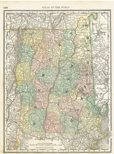
1886 Maps of Vermont /New Hampshire and Maine

US $9.86
Condition:
“Margins are trimmed close on both maps . No Stains (margins not affecting maps), Foxing or Writing. ”... Read moreabout condition
- Buy It Now1886 Maps of Vermont /New Hampshire and Maine
Oops! Looks like we're having trouble connecting to our server.
Refresh your browser window to try again.
Shipping:
US $5.35 USPS Ground Advantage®.
Located in: Wilmington, North Carolina, United States
Delivery:
Estimated between Thu, Jul 24 and Wed, Jul 30 to 94104
Returns:
14 days returns. Buyer pays for return shipping. If you use an eBay shipping label, it will be deducted from your refund amount.
Payments:
Special financing available. See terms and apply now- for PayPal Credit, opens in a new window or tab
Earn up to 5x points when you use your eBay Mastercard®. Learn moreabout earning points with eBay Mastercard
Shop with confidence
Seller assumes all responsibility for this listing.
eBay item number:196490818296
Item specifics
- Seller Notes
- Date Range
- 1886
- Type
- County Map
- Printing Technique
- Lithography
- Format
- Atlas Map
- US State
- Maine, New Hampshire, Vermont
- Year
- 1886
- Original/Reproduction
- Antique Original
- Cartographer/Publisher
- Rand McNally & Co.
- Country/Region
- United States of America
Item description from the seller

Seller feedback (3,983)
- *****- Feedback left by buyer.Past 6 monthsVerified purchaseGood seller. Combined shipping is cheap. Nice packaging and the item is as described. Great value!
- *****- Feedback left by buyer.Past 6 monthsVerified purchaseMap was sent in a tube that couldn't cause damage to the map. The map was in great condition.
- *****- Feedback left by buyer.Past 6 monthsVerified purchaseItem was as described. It was packed well enough and shipped quickly. I believe it is a good value.
More to explore :
- Antique North American Maps & Atlases New Hampshire,
- New Hampshire Antique North America Wall Maps,
- New Hampshire Topographical Map Antique North America Folding Maps,
- New Hampshire Topographical Map Antique North America Sheet Maps,
- New Hampshire Antique North America Folding Maps,
- New Hampshire Antique North America Nautical Maps,
- New York New Hampshire Antique North America Maps & Atlases,
- Washington New Hampshire Antique North America Maps & Atlases,
- New Hampshire County Map Antique North America Atlas,
- New York Vermont Antique North America Maps & Atlases
Seller feedback (3,983)
- *****- Feedback left by buyer.Past 6 monthsVerified purchaseGood seller. Combined shipping is cheap. Nice packaging and the item is as described. Great value!
- *****- Feedback left by buyer.Past 6 monthsVerified purchaseMap was sent in a tube that couldn't cause damage to the map. The map was in great condition.
- *****- Feedback left by buyer.Past 6 monthsVerified purchaseItem was as described. It was packed well enough and shipped quickly. I believe it is a good value.