
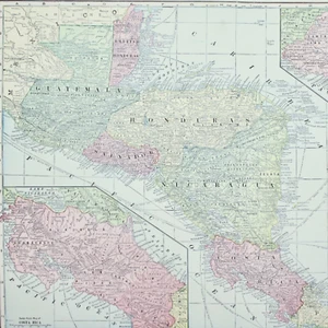
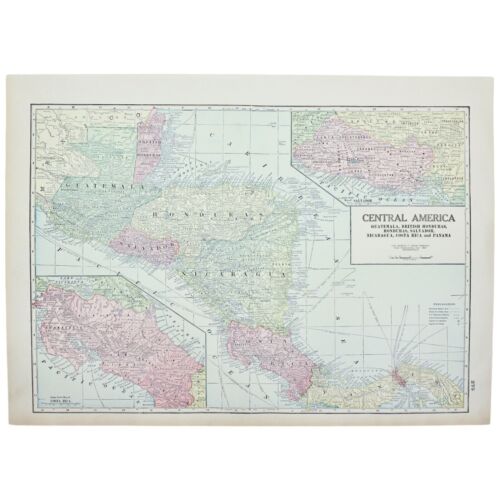
COSTA RICA PANAMA MAP Large Antique FULL COLOR 1928 21"x14" CENTRAL AMERICA
US $52.50US $52.50
Sun, May 04, 11:16 AMSun, May 04, 11:16 AM
Picture 1 of 2
Gallery
Picture 1 of 2


Have one to sell?
COSTA RICA PANAMA MAP Large Antique FULL COLOR 1928 21"x14" CENTRAL AMERICA
US $52.50
or Best Offer
Condition:
“Very Good Used condition, there are no tears to the printed area but there may be small tears to the ”... Read moreabout condition
Oops! Looks like we're having trouble connecting to our server.
Refresh your browser window to try again.
Shipping:
US $13.45 USPS Ground Advantage®.
Located in: Tonawanda, New York, United States
Delivery:
Estimated between Sat, Aug 2 and Fri, Aug 8 to 94104
Returns:
30 days returns. Seller pays for return shipping.
Payments:
.
Special financing available. See terms and apply now- for PayPal Credit, opens in a new window or tab
Earn up to 5x points when you use your eBay Mastercard®. Learn moreabout earning points with eBay Mastercard
Shop with confidence
Seller assumes all responsibility for this listing.
eBay item number:197221854930
Item specifics
- Seller Notes
- Country/Region
- Costa Rica, Panama, CENTRAL AMERICA
- Date Range
- 1920-1929
- Original/Reproduction
- Vintage Original
- Format
- Atlas Map
- City
- MULTIPLE
- Type
- World Atlas
- Printing Technique
- Cerographic Engraving
- Cartographer/Publisher
- George F. Cram Company
- Year
- 1928
Item description from the seller
Seller Feedback
No feedback yet
More to explore :
- Costa Rica Antique Central America/Caribbean Atlas Maps,
- Costa Rica Antique Central America/Caribbean Maps & Atlases,
- Panama Antique Central America/Caribbean Maps & Atlases,
- Costa Rica Antique Original Antique Central American/Caribbean Maps & Atlases,
- Costa Rica 1800-1899 Date Range Antique Central America/Caribbean Maps & Atlases,
- Panama 1900-1909 Date Range Antique Central America/Caribbean Maps & Atlases,
- Antique Central America/Caribbean Political Maps,
- Antique Central America/Caribbean Folding Maps,
- Antique Central America/Caribbean Topographical Maps,
- County Map Antique Central America/Caribbean Atlas Maps