
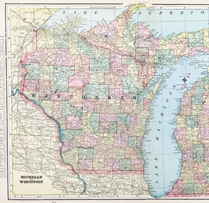
1899 MICHIGAN WISCONSIN Map ORIGINAL (18x12) UPPER PENINSULA Lake Superior
US $34.88US $34.88
Wed, May 14, 06:53 PMWed, May 14, 06:53 PM
Picture 1 of 4


Gallery
Picture 1 of 4


Have one to sell?
1899 MICHIGAN WISCONSIN Map ORIGINAL (18x12) UPPER PENINSULA Lake Superior
US $34.88
or Best Offer
Condition:
Oops! Looks like we're having trouble connecting to our server.
Refresh your browser window to try again.
Shipping:
Free USPS Ground Advantage®.
Located in: Monroe, Georgia, United States
Delivery:
Estimated between Tue, Jul 15 and Mon, Jul 21 to 94104
Returns:
30 days returns. Seller pays for return shipping.
Payments:
Earn up to 5x points when you use your eBay Mastercard®. Learn moreabout earning points with eBay Mastercard
Shop with confidence
Seller assumes all responsibility for this listing.
eBay item number:226700460952
Item specifics
- Date Range
- 1800-1899
- Type
- Railroad Map
- US State
- Michigan, Wisconsin
- Format
- Atlas Map
- Printing Technique
- Lithography
- Year
- 1899
- Cartographer/Publisher
- George Cram
- Original/Reproduction
- Antique Original
- City
- Marquette
- Country/Region
- United States of America
Item description from the seller
Seller Feedback
No feedback yet
More to explore :
- Wisconsin Original 1800-1899 Antique North America Maps & Atlases,
- Wisconsin Vintage Original Antique North American Maps & Atlases 1800-1899 Date Range,
- Wisconsin Antique Original Antique North American Maps & Atlases 1800-1899 Date Range,
- Antique Wisconsin Maps & Atlases,
- Wisconsin 1800-1899 Date Range Antique North America County Maps,
- Wisconsin Antique Original Antique North America City Maps,
- Original 1800-1899 Antique World Maps & Atlases,
- Michigan 1800-1899 Date Range Antique North America City Maps,
- Michigan Antique Original Antique North America County Maps,
- Michigan Antique Original Antique North America Railroad Maps