
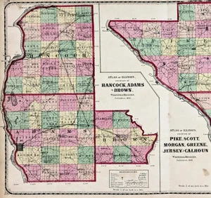
1870 ILLINOIS County Map PIKE SCOTT HANCOCK ADAMS MORGAN CALHOUN JERSEY ADAMS
US $34.00US $34.00
Wed, May 14, 06:52 PMWed, May 14, 06:52 PM
Picture 1 of 4


Gallery
Picture 1 of 4


Have one to sell?
1870 ILLINOIS County Map PIKE SCOTT HANCOCK ADAMS MORGAN CALHOUN JERSEY ADAMS
US $34.00
or Best Offer
Condition:
“GOOD CONDITION-DISCOLORATION, CENTER FOLDING AS ISSUED”
Oops! Looks like we're having trouble connecting to our server.
Refresh your browser window to try again.
Shipping:
Free USPS Ground Advantage®.
Located in: Monroe, Georgia, United States
Delivery:
Estimated between Wed, Jul 30 and Mon, Aug 4 to 94104
Returns:
30 days returns. Seller pays for return shipping.
Payments:
Special financing available. See terms and apply now- for PayPal Credit, opens in a new window or tab
Earn up to 5x points when you use your eBay Mastercard®. Learn moreabout earning points with eBay Mastercard
Shop with confidence
Seller assumes all responsibility for this listing.
eBay item number:226719708527
Item specifics
- Seller Notes
- “GOOD CONDITION-DISCOLORATION, CENTER FOLDING AS ISSUED”
- Date Range
- 1800-1899
- Type
- MAP
- US State
- IL, IN, MI, OH, WI, Illinois
- Format
- Atlas Map
- Printing Technique
- Lithography
- Year
- 1870
- Source-
- Atlas of Edgar County and the state of Illinois 1870 Philadelphia
- Original/Reproduction
- Antique Original
- Cartographer/Publisher
- WARNER & HIGGINS
- ORIGINAL MAP
- Antique 154 year old map
- City
- QUINCY
- Country/Region
- United States of America
Item description from the seller
Seller Feedback
No feedback yet
More to explore :
- Illinois County Map Antique North America Atlas Maps,
- Illinois Antique North America County Maps,
- Illinois County Map Antique North America Folding Maps,
- Illinois County Map Antique North America Atlas,
- Washington Illinois Antique North America County Maps,
- Antique County Maps,
- Salem New Jersey Antique North America County Maps,
- County Map Antique School Maps,
- County Map Antique Wall Maps,
- County Map Antique Europe Atlas Maps