Picture 1 of 6


Gallery
Picture 1 of 6


Have one to sell?
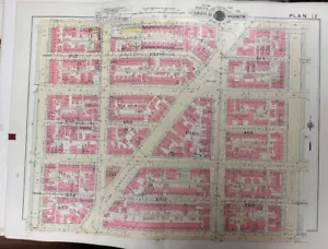
1957 WASHINGTON DC ANACOSTIA 13th ST TO 16th ST & T ST TO FLORIDA AV ATLAS MAP
US $99.95
or 4 interest-free payments of $24.99 available with
Condition:
“ORIGINAL HAND COLORED ON LINEN 24 1/2 X35. VG+/EXCELLENT CONDITION”
- Buy It Now1957 WASHINGTON DC ANACOSTIA 13th ST TO 16th ST & T ST TO FLORIDA AV ATLAS MAP
Oops! Looks like we're having trouble connecting to our server.
Refresh your browser window to try again.
Shipping:
US $20.65 USPS Ground Advantage®.
Located in: Floral Park, New York, United States
Delivery:
Estimated between Wed, Jul 30 and Wed, Aug 6 to 94104
Returns:
14 days returns. Buyer pays for return shipping. If you use an eBay shipping label, it will be deducted from your refund amount.
Payments:
.
4 interest-free payments of $24.99 available with Klarna.
Special financing available. See terms and apply now- for PayPal Credit, opens in a new window or tab
Earn up to 5x points when you use your eBay Mastercard®. Learn moreabout earning points with eBay Mastercard
Shop with confidence
Seller assumes all responsibility for this listing.
eBay item number:235364968077
Item specifics
- Seller Notes
- “ORIGINAL HAND COLORED ON LINEN 24 1/2 X35. VG+/EXCELLENT CONDITION”
- Type
- River Map
- Format
- Atlas Map
- US State
- Washington D.C.
- Year
- 1957
- Cartographer/Publisher
- R.H. BAIST
- Original/Reproduction
- Antique Original
- City
- Washington D.C.
Item description from the seller
Seller feedback (2,618)
- y***r (117)- Feedback left by buyer.Past monthVerified purchaseAlthough shipping took longer than expected, it was very well packaged and the item was very well described. It is a wonderful piece of our family history
- v***d (1693)- Feedback left by buyer.Past 6 monthsVerified purchaseA very rare and specialized item, it was exactly as described, packed well and sent quickly. I am very pleased! Thank you!
- d***d (55)- Feedback left by buyer.Past 6 monthsVerified purchaseThank you so much. What a wonderful map!Thanks also for taking such care in wrapping for shipment. Very happy. Hope to do business again with you.ORIG 1903 ORANGE COUNTY NY WARWICK BELLVALE NEW MILFORD STATION PLAT ATLAS MAP (#235110784667)
More to explore :
- St. Louis Antique North America Atlas Maps,
- St. Louis Missouri Antique North America Atlas Maps,
- St. Louis Antique North America Atlas,
- St. Louis Antique North America Railroad Maps,
- St. Louis Antique North America River Maps,
- St. Louis Antique North America County Maps,
- St. Louis Antique North America City Maps,
- St. Louis Kansas Antique North America City Maps,
- St. Louis Illinois Antique North America Maps & Atlases,
- Washington Railroad Map Antique North America Atlas Maps