
Picture 1 of 5


Gallery
Picture 1 of 5


Have one to sell?
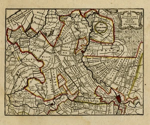
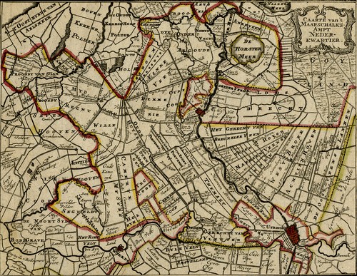
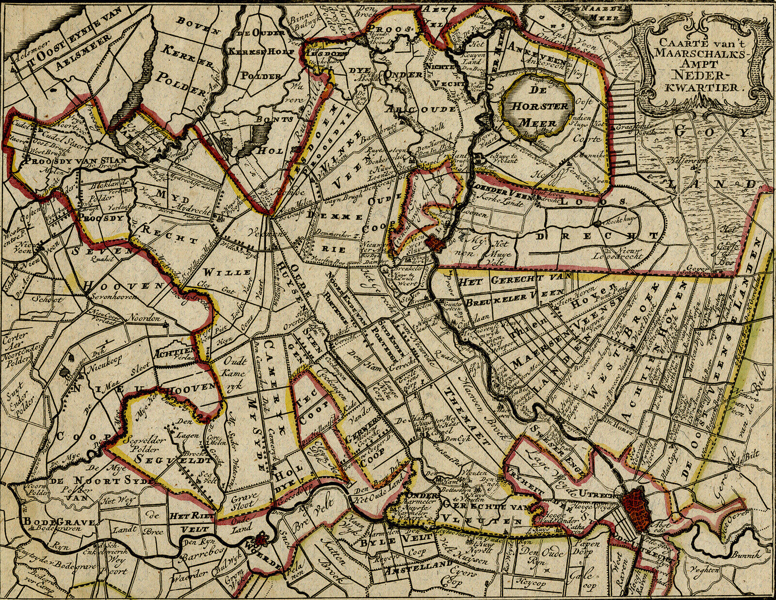
Antique Map-TOPOGRAPHY

US $187.50
or Best Offer
$168.75 with coupon code
as low as $32.54/mo with
Condition:
“Good, given age. Small margins. General age-related toning and/or occasional minor defects from ”... Read moreabout condition
- Buy It NowAntique Map-TOPOGRAPHY-NEDERKWARTIER-UTRECHT-NETHERLAND-DE LETH-Anonymous-1765
Oops! Looks like we're having trouble connecting to our server.
Refresh your browser window to try again.
Shipping:
Free Standard Shipping from outside US.
International shipment of items may be subject to customs processing and additional charges.
Located in: Zeeland, Netherlands
Delivery:
Estimated between Thu, Jul 31 and Wed, Aug 20 to 94104
Returns:
30 days returns. Buyer pays for return shipping. If you use an eBay shipping label, it will be deducted from your refund amount.
Payments:
.
As low as $32.54/mo with Klarna.
*No Interest if paid in full in 6 months on $149+. See terms and apply now- for PayPal Credit, opens in a new window or tab
Earn up to 5x points when you use your eBay Mastercard®. Learn moreabout earning points with eBay Mastercard
Shop with confidence
Seller assumes all responsibility for this listing.
eBay item number:235440947604
Item specifics
- Seller Notes
- Artist
- Anonymous
- Subject
- Maps
- Features
- Unframed
- Medium
- Engraving
- Style
- Realism
- Size
- Small
- Height (Inches)
- 8.3
- Width (Inches)
- 9.8
- Height (Centimeters)
- 21.0
- Width (Centimeters)
- 25.0
- Orientation
- Landscape
- Size (CM)
- Small (up to 30 cm wide)
- Type
- Topographical Map
- Culture
- European
- Material
- Paper
- Original/Licensed Reprint
- Original
- Production Technique
- Engraving
- Region of Origin
- Europe
- Theme
- Topographical
- Year of Production
- 1765
- Framing
- Unframed
- Image Orientation
- Landscape
- Signed
- No
- Unit of Sale
- Single Piece
- Color
- Multi-Color
- Item Length
- Not applicable
- Country/Region of Manufacture
- Europe
- Time Period Produced
- 1750-1799
- Item Height
- 9.8 in
- Item Width
- 8.4 in
- Country/Region
- Netherlands
- City
- Not applicable
- Date Range
- 1700-1799
- Original/Reproduction
- Antique Original
- Format
- Atlas Map
- Cartographer/Publisher
- Hendrik de Leth
- Printing Technique
- Copper Plate
- Year
- 1765
- Publisher
- Hendrik de Leth
- County
- Not applicable
Item description from the seller
Seller business information
VAT number: NL 820763196B01

Popular categories from this store
Seller feedback (8,580)
- o***e (930)- Feedback left by buyer.Past 6 monthsVerified purchaseReceived as advertised & quickly from The Netherlands. Wanted some type of art related to forefather-born name Dallicker (some art Dalliker). I was kind of anxious opening package uncertain or original as I never dealt in original sketches and paintings so i did not know what to expect, then I realize the expertise of the seller - original 1760 paper & the COA as I was wondering of provenance - so the two page document with signature was appreciated & relied on positive Feedback
- h***8 (1737)- Feedback left by buyer.Past 6 monthsVerified purchaseExcellent seller! Beautiful vintage print as described, very carefully packaged for shipping, fast international shipping (Netherlands to US) with tracking, outstanding!
- 4***g (197)- Feedback left by buyer.Past 6 monthsVerified purchaseGreat seller! Shipped quickly, packaged well, arrived as described.
More to explore :
- Antique European Maps & Atlases Utrecht Netherlands,
- Utrecht Netherlands Antique Original Antique European Maps & Atlases,
- Utrecht Netherlands 1800-1899 Date Range Antique Europe Maps & Atlases,
- Utrecht Netherlands Antique European Maps & Atlases 1700-1799 Date Range,
- Antique European Maps & Atlases Utrecht,
- Antique European Maps & Atlases Netherlands,
- Netherlands Antique Europe Sheet Maps,
- Netherlands Lithography Antique Europe City Maps,
- Amsterdam Netherlands Antique Original Antique European Maps & Atlases,
- Antique European Maps & Atlases Utrecht 1800-1899 Date Range
Popular categories from this store
Seller feedback (8,580)
- o***e (930)- Feedback left by buyer.Past 6 monthsVerified purchaseReceived as advertised & quickly from The Netherlands. Wanted some type of art related to forefather-born name Dallicker (some art Dalliker). I was kind of anxious opening package uncertain or original as I never dealt in original sketches and paintings so i did not know what to expect, then I realize the expertise of the seller - original 1760 paper & the COA as I was wondering of provenance - so the two page document with signature was appreciated & relied on positive Feedback
- h***8 (1737)- Feedback left by buyer.Past 6 monthsVerified purchaseExcellent seller! Beautiful vintage print as described, very carefully packaged for shipping, fast international shipping (Netherlands to US) with tracking, outstanding!
- 4***g (197)- Feedback left by buyer.Past 6 monthsVerified purchaseGreat seller! Shipped quickly, packaged well, arrived as described.