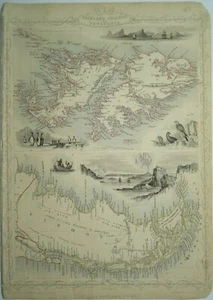


Antique map of The Falkland Islands and Patagonia by John Tallis 1851
GBP 70.00
ApproximatelyUS $93.14
Condition:
- Buy It NowAntique map of The Falkland Islands and Patagonia by John Tallis 1851
Oops! Looks like we're having trouble connecting to our server.
Refresh your browser window to try again.
Shipping:
GBP 10.00 (approx US $13.31) Royal Mail International Signed.
International shipment of items may be subject to customs processing and additional charges.
Located in: Bath, United Kingdom
Delivery:
Estimated between Wed, May 21 and Thu, May 29 to 43230
Includes 5 business days handling time after receipt of cleared payment.
Please allow additional time if international delivery is subject to customs processing.
Returns:
Seller does not accept returns.
Payments:
Earn up to 5x points when you use your eBay Mastercard®. Learn moreabout earning points with eBay Mastercard
Shop with confidence
Seller assumes all responsibility for this listing.
eBay item number:254981008072
Item specifics
- Cartographer/Publisher
- John Tallis
- Printing Technique
- Steel engraved
- Original/Reproduction
- Antique Original
- Region
- South America, Patagonia, Argentina, Falkland Isla
- Type
- Topographical Map
- Year
- 1851
- Antique
- Yes
- Date Range
- 1800-1899
- Era
- 1800s
Item description from the seller

Seller feedback (445)
- *****- Feedback left by buyer.Past 6 monthsVerified purchaseGreat thank you. Fast shipping, well packaged, item arrived in expected condition as described. x
- .***p (108)- Feedback left by buyer.Past yearVerified purchaseGreat map, well priced and exactly as described. Packed securely and posted very promptly. I’ll absolutely be buying again.Antique map of Scotland by Thomas Kitchin 1784 (#256164248072)
- t***a (246)- Feedback left by buyer.Past 6 monthsVerified purchaseArrived promptly and well packed. Item as described.Antique map of Kent by Richard Blome 1715 (#256392245593)
This is a private listing and your identity will not be disclosed to anyone except the seller.
More to explore :
- Antique South American Maps & Atlases Falkland Islands,
- Falkland Islands Antique Original Antique South America Maps & Atlases,
- John Bartholomew Political Map Antique Atlas Maps,
- John Cary Antique Atlas Maps,
- John Bartholomew Antique Topographical Maps,
- Rhode Island Antique North America Nautical Maps,
- Cook Islands Antique Australia/Oceania Maps & Atlases,
- John Cary Antique Maps, Atlases & Globes,
- Virgin Islands Antique Central American/Caribbean Maps & Atlases,
- Antique European Maps & Atlases John Bartholomew
Seller feedback (445)
- *****- Feedback left by buyer.Past 6 monthsVerified purchaseGreat thank you. Fast shipping, well packaged, item arrived in expected condition as described. x
- .***p (108)- Feedback left by buyer.Past yearVerified purchaseGreat map, well priced and exactly as described. Packed securely and posted very promptly. I’ll absolutely be buying again.Antique map of Scotland by Thomas Kitchin 1784 (#256164248072)
- t***a (246)- Feedback left by buyer.Past 6 monthsVerified purchaseArrived promptly and well packed. Item as described.Antique map of Kent by Richard Blome 1715 (#256392245593)