
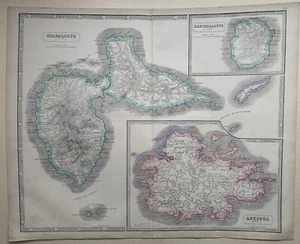
1855 Guadeloupe, Marie Galante, Antigua Large Hand Coloured Map by George Philip
GBP 60.00GBP 60.00
Sun, May 04, 10:31 PMSun, May 04, 10:31 PM
Picture 1 of 6


Gallery
Picture 1 of 6


Have one to sell?
1855 Guadeloupe, Marie Galante, Antigua Large Hand Coloured Map by George Philip
GBP 60.00
ApproximatelyUS $80.50
or Best Offer
Condition:
“The map has a small marginal split in the centrefold which has been repaired.”
Oops! Looks like we're having trouble connecting to our server.
Refresh your browser window to try again.
Shipping:
GBP 12.00 (approx US $16.10) Parcelforce Global Express.
International shipment of items may be subject to customs processing and additional charges.
Located in: Manchester, United Kingdom
Delivery:
Estimated between Mon, Jul 28 and Thu, Jul 31 to 94104
Returns:
60 days returns. Seller pays for return shipping.
Payments:
Earn up to 5x points when you use your eBay Mastercard®. Learn moreabout earning points with eBay Mastercard
Shop with confidence
Seller assumes all responsibility for this listing.
eBay item number:255616675782
Item specifics
- Seller Notes
- “The map has a small marginal split in the centrefold which has been repaired.”
- Date Range
- 1800-1899
- Antique
- Yes
- Type
- Political Map
- Format
- Atlas Map
- Year
- 1855
- Era
- 1800s
- Original/Reproduction
- Antique Original
- Cartographer/Publisher
- George Philip
- Country/Region
- Antigua and Barbuda
Item description from the seller
Seller Feedback
No feedback yet
More to explore :
- George Cram Railroad Map Antique Atlas Maps,
- George Cram City Map Antique Atlas Maps,
- George Cram Political Map Antique Atlas Maps,
- George Cram Antique Physical Maps,
- Georg Braun Antique Atlas Maps,
- George Cram Antique Pull Down Maps,
- Antique European Maps & Atlases Georg Braun,
- George Cram Antique World Atlas Maps,
- Georg Braun Antique Maps, Atlases & Globes,
- George Cram Antique Europe Political Maps