Picture 1 of 6


Gallery
Picture 1 of 6


Have one to sell?
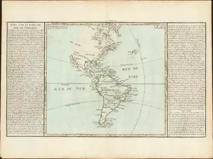
1767 America's Islands, Capes & Seaports antique map by Clouet ~ 22.8" x 17.1"
US $175.00
as low as $30.37/mo with
Condition:
- Buy It Now1767 America's Islands, Capes & Seaports antique map by Clouet ~ 22.8" x 17.1"
Oops! Looks like we're having trouble connecting to our server.
Refresh your browser window to try again.
Shipping:
US $10.00 USPS First Class®.
Located in: Jacksonville, Florida, United States
Delivery:
Estimated between Sat, Aug 2 and Fri, Aug 8 to 94104
Returns:
30 days returns. Buyer pays for return shipping. If you use an eBay shipping label, it will be deducted from your refund amount.
Payments:
.
As low as $30.37/mo with Klarna.
*No Interest if paid in full in 6 months on $149+. See terms and apply now- for PayPal Credit, opens in a new window or tab
Earn up to 5x points when you use your eBay Mastercard®. Learn moreabout earning points with eBay Mastercard
Shop with confidence
Seller assumes all responsibility for this listing.
eBay item number:256133403788
Item specifics
- Date Range
- 1700-1799
- Type
- Physical Map
- US State
- AK, HI, AL, FL, GA, MS, NC, SC, AR, IA, KS, LA, MO, NE, AZ, CA, CO, NM, NV, UT, CT, MA, ME, NH, RI, VT, DC, DE, MD, NJ, NY, PA, ID, OR, WA, IL, IN, MI, OH, WI, MN, MT, ND, SD, WY, OK, TX, VA, WV, KY, TN
- Format
- Atlas Map
- Mexican State
- Aguascalientes, Baja California, Chiapas, Chihuahua, Guerrero, Hidalgo, Jalisco, Michoacán, Morelos, Nayarit, Nuevo León, Oaxaca, Puebla, Querétaro, Quintana Roo, San Luis Potosí, Sinaloa, Sonora, Tabasco, Tamaulipas, Tlaxcala, Veracruz
- Printing Technique
- Copper Plate
- Canadian Province
- Alberta, British Columbia, Manitoba, New Brunswick, Newfoundland & Labrador, Northwest Territories, Nova Scotia, Nunavut, Ontario, Prince Edward Island, Quebec, Saskatchewan, Yukon
- Year
- 1767
- Original/Reproduction
- Antique Original
- Cartographer/Publisher
- Clouet
- City
- New York
- Country/Region
- Canada
Item description from the seller
Popular categories from this store
Seller feedback (1,553)
- b***b (1618)- Feedback left by buyer.Past 6 monthsVerified purchaseSeller was a big help in sorting out the stupidity of the USPS and their "tracking" the delivery as it sat at the various post offices. There shipping time was completely screwed up by USPS. It finally arrived today, 19 days after being sent on May 4. The map was carefully packed and arrived in better-than-expected condition. It was accurately described with clear & beautiful colors. Well worth the price.
- s***s (323)- Feedback left by buyer.Past monthVerified purchaseGreat seller! Product was as described, good communication and Stein was well packaged and fast shipping too, very happy. Would definitely buy from again
- d***e (238)- Feedback left by buyer.Past 6 monthsVerified purchaseGood price. Great communication. Quick shipment. Excellent packaging. Love it! I would definitely buy from this seller again. Thank you!
More to explore :
- Rhode Island Antique North America Nautical Maps,
- Rhode Island Antique North America City Maps,
- Rhode Island Antique North America Folding Maps,
- Rhode Island Antique North America Railroad Maps,
- Rhode Island Antique North America County Maps,
- Falkland Islands Antique Original Antique South America Maps & Atlases,
- Newport Rhode Island Antique North America Maps & Atlases,
- Providence Rhode Island Antique North America City Maps,
- Vintage Reproduction Rhode Island Antique North America Maps & Atlases,
- Copper Plate Rhode Island Antique North America Atlas Maps