Picture 1 of 3


Gallery
Picture 1 of 3


Have one to sell?
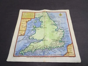
Antique map of England and Wales Sea Coast by Thomas Badeslade 1741

GBP 35.00
ApproximatelyUS $47.29
Condition:
- Buy It NowAntique map of England and Wales Sea Coast by Thomas Badeslade 1741
Oops! Looks like we're having trouble connecting to our server.
Refresh your browser window to try again.
Shipping:
GBP 10.00 (approx US $13.51) Royal Mail International Signed.
International shipment of items may be subject to customs processing and additional charges.
Located in: Bath, United Kingdom
Delivery:
Estimated between Wed, Jul 30 and Thu, Aug 7 to 94104
Returns:
Seller does not accept returns.
Payments:
Earn up to 5x points when you use your eBay Mastercard®. Learn moreabout earning points with eBay Mastercard
Shop with confidence
Seller assumes all responsibility for this listing.
eBay item number:256646802842
Item specifics
- Date Range
- 1700-1799
- Type
- Topographical Map
- Printing Technique
- Copper Plate
- Year
- 1741
- Era
- 1700s
- Cartographer/Publisher
- Thomas Badeslade
- Original/Reproduction
- Antique Original
- Country/Region
- England, Wales
Item description from the seller

Seller feedback (483)
- *****- Feedback left by buyer.Past 6 monthsVerified purchaseGreat thank you. Fast shipping, well packaged, item arrived in expected condition as described. x
- 0***1 (1574)- Feedback left by buyer.Past 6 monthsVerified purchaseReceived OK, great map, well packaged, easy transaction, A1.
- o***y (58)- Feedback left by buyer.Past monthVerified purchaseWell packaged and quick dispatch.
More to explore :
- Wales Antique Europe Railroad Maps,
- Wales Antique Europe Sheet Maps,
- Wales Antique Europe Folding Maps,
- Wales Antique Europe Maps & Atlases,
- Wales Antique Europe Atlas Maps,
- Wales Lithography Antique Europe Atlas Maps,
- Wales Copper Plate Antique Europe Folding Maps,
- England Antique Europe Maps & Atlases,
- Wales Copper Plate Antique Europe Atlas Maps,
- Liverpool Wales London Antique Europe Maps & Atlases
Seller feedback (483)
- *****- Feedback left by buyer.Past 6 monthsVerified purchaseGreat thank you. Fast shipping, well packaged, item arrived in expected condition as described. x
- 0***1 (1574)- Feedback left by buyer.Past 6 monthsVerified purchaseReceived OK, great map, well packaged, easy transaction, A1.
- o***y (58)- Feedback left by buyer.Past monthVerified purchaseWell packaged and quick dispatch.