
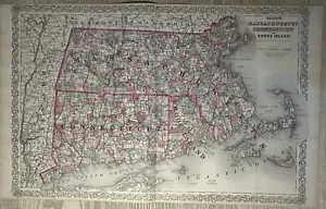
1870 Colton's Massachusetts Connecticut & Rhode Island Antique Map 28" x 17"
GBP 69.99GBP 69.99
Fri, May 02, 04:12 AMFri, May 02, 04:12 AM


1870 Colton's Massachusetts Connecticut & Rhode Island Antique Map 28" x 17"
GBP 69.99
ApproximatelyUS $94.20
or Best Offer
Condition:
“The map is in good condition for its age.”
Oops! Looks like we're having trouble connecting to our server.
Refresh your browser window to try again.
Shipping:
GBP 12.00 (approx US $16.15) Parcelforce Global Express.
International shipment of items may be subject to customs processing and additional charges.
Located in: Manchester, United Kingdom
Delivery:
Estimated between Tue, Jun 10 and Fri, Jun 13 to 94104
Returns:
60 days returns. Seller pays for return shipping.
Payments:
Earn up to 5x points when you use your eBay Mastercard®. Learn moreabout earning points with eBay Mastercard
Shop with confidence
Seller assumes all responsibility for this listing.
eBay item number:256770519433
Item specifics
- Seller Notes
- “The map is in good condition for its age.”
- Antique
- Yes
- Date Range
- 1800-1899
- Type
- Political Map
- Format
- Atlas Map
- US State
- Massachusetts
- Year
- 1870
- Era
- 1800s
- Cartographer/Publisher
- Joseph Colton
- Original/Reproduction
- Antique Original
- Country/Region
- United States of America
Item description from the seller
Seller Feedback
No feedback yet
More to explore :
- Rhode Island Antique North America Nautical Maps,
- Rhode Island Antique North America County Maps,
- Rhode Island Antique North America Railroad Maps,
- Rhode Island Antique North America City Maps,
- Antique North American Maps & Atlases Rhode Island,
- Newport Rhode Island Antique North America Maps & Atlases,
- Providence Rhode Island Antique North America Atlas Maps,
- Providence Rhode Island Antique North America County Maps,
- Vintage Reproduction Rhode Island Antique North America Maps & Atlases,
- Copper Plate Rhode Island Antique North America Atlas Maps