
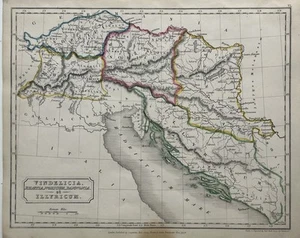
1829 Ancient Vindelicia Rhaetia Noricum Pannonia Illyricum Hand Coloured Map
GBP 19.99GBP 19.99
Sat, May 17, 02:04 AMSat, May 17, 02:04 AM
Picture 1 of 5


Gallery
Picture 1 of 5


Have one to sell?
1829 Ancient Vindelicia Rhaetia Noricum Pannonia Illyricum Hand Coloured Map
GBP 19.99
ApproximatelyUS $27.01
or Best Offer
Condition:
“The map is in good condition for its age.”
Oops! Looks like we're having trouble connecting to our server.
Refresh your browser window to try again.
Shipping:
GBP 5.00 (approx US $6.76) Royal Mail International Standard.
International shipment of items may be subject to customs processing and additional charges.
Located in: Manchester, United Kingdom
Delivery:
Estimated between Wed, Jul 30 and Tue, Aug 12 to 94104
Returns:
60 days returns. Seller pays for return shipping.
Payments:
Earn up to 5x points when you use your eBay Mastercard®. Learn moreabout earning points with eBay Mastercard
Shop with confidence
Seller assumes all responsibility for this listing.
eBay item number:256897263110
Item specifics
- Seller Notes
- “The map is in good condition for its age.”
- Date Range
- 1800-1899
- Antique
- Yes
- Type
- Political Map
- Format
- Atlas Map
- Year
- 1829
- Era
- 1800s
- Cartographer/Publisher
- Sidney Hall
- Original/Reproduction
- Antique Original
- Country/Region
- Croatia, Germany, Italy, Austria, Slovenia
Item description from the seller
Seller Feedback
No feedback yet
More to explore :
- Manuscript/Hand drawn County Map Antique Sheet Maps,
- Manuscript/Hand drawn Antique Sheet Maps,
- Manuscript/Hand drawn Antique County Maps,
- Manuscript/Hand drawn County Map Antique North America Sheet Maps,
- Manuscript/Hand drawn Antique Maps, Atlases & Globes,
- Manuscript/Hand drawn Antique North America Sheet Maps,
- Antique Original Manuscript/Hand drawn Antique Sheet Maps,
- United States of America Manuscript/Hand drawn Antique North American Maps & Atlases,
- Political Map Antique Atlas Maps,
- County Map Antique Atlas Maps