
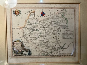
ORIGINAL 1760s Map Of Leicestershire By T.Kitchin Hand Coloured
GBP 64.00GBP 64.00
Fri, May 02, 06:42 AMFri, May 02, 06:42 AM
Picture 1 of 9


Gallery
Picture 1 of 9


Have one to sell?
ORIGINAL 1760s Map Of Leicestershire By T.Kitchin Hand Coloured
Condition:
Ended: May 02, 2025 06:42:15 PDT
Oops! Looks like we're having trouble connecting to our server.
Refresh your browser window to try again.
Shipping:
GBP 30.85 (approx US $41.46) International Priority Shipping to United States via eBay's Global Shipping Program.
Located in: Freshwater, United Kingdom
Import charges:
Free amount confirmed at checkout
Delivery:
Estimated between Fri, Aug 8 and Fri, Aug 15 to 94104
Includes international tracking
Returns:
Seller does not accept returns.
Payments:
Earn up to 5x points when you use your eBay Mastercard®. Learn moreabout earning points with eBay Mastercard
Shop with confidence
Seller assumes all responsibility for this listing.
eBay item number:277063863827
Item specifics
- County
- Leicestershire
- Year
- 1760
- Antique
- Yes
- Date Range
- 1700-1799
- Type
- County Map
- Format
- Sheet Map
- Printing Technique
- Copper Plate
- Era
- 1700s
- Cartographer/Publisher
- Thomas Kitchin
- Original/Reproduction
- Antique Original
- Country/Region
- United Kingdom, England
Item description from the seller
Seller Feedback
No feedback yet
More to explore :
- Thomas Kitchin Antique Original Antique Maps, Atlases & Globes,
- Antique European Maps & Atlases Leicestershire,
- Antique European Maps & Atlases Thomas Kitchin,
- Thomas Kitchin Antique Maps, Atlases & Globes,
- Thomas Kitchin Antique Original Antique Maps, Atlases & Globes 1700-1799 Date Range,
- Antique Original Manuscript/Hand drawn Antique Maps, Atlases & Globes,
- Antique Original Nautical Map Antique Atlas Maps,
- Antique Original Railroad Map Antique Atlas Maps,
- Antique Original City Map Antique Atlas Maps,
- Antique Original County Map Antique Atlas Maps