
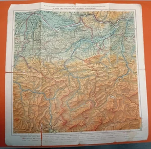
MAPS 1926 OF THE POLITICAL DISTRICT OF AMSTETTEN Austria 47,5 x 47,5 cm
US $25.00US $25.00
Fri, Jun 13, 03:30 AMFri, Jun 13, 03:30 AM
Picture 1 of 7


Gallery
Picture 1 of 7


Have one to sell?
MAPS 1926 OF THE POLITICAL DISTRICT OF AMSTETTEN Austria 47,5 x 47,5 cm
US $25.00
Condition:
“CONDITION AS IN PICTURES”
Oops! Looks like we're having trouble connecting to our server.
Refresh your browser window to try again.
Shipping:
US $9.00 Standard Shipping.
International shipment of items may be subject to customs processing and additional charges.
Located in: SERBIA, SERBIA, Serbia
Delivery:
Estimated between Sat, Jul 26 and Tue, Jul 29 to 94104
Returns:
Seller does not accept returns.
Payments:
Special financing available. See terms and apply now- for PayPal Credit, opens in a new window or tab
Earn up to 5x points when you use your eBay Mastercard®. Learn moreabout earning points with eBay Mastercard
Shop with confidence
Seller assumes all responsibility for this listing.
eBay item number:285646320043
Item specifics
- Seller Notes
- “CONDITION AS IN PICTURES”
- Date Range
- 1920-1929
- Type
- Political Map
- Format
- Folding Map
- Year
- 1926
- Original/Reproduction
- Vintage Original
- City
- Munich
- Country/Region
- Austria
- County
- Austria
Item description from the seller
Seller Feedback
No feedback yet
This is a private listing and your identity will not be disclosed to anyone except the seller.
More to explore :
- Austria Antique Europe Political Maps,
- Austria Political Map Antique Europe Atlas Maps,
- Austria 1800-1899 Date Range Antique Europe Political Maps,
- Antique Political Maps,
- Austria Antique Europe Topographical Maps,
- Antique Asia Political Maps,
- Political Map Antique Folding Maps,
- Austria Antique Europe City Maps,
- Antique Africa Political Maps,
- Political Map Antique Europe Sheet Maps