
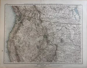
1898-1910 Northwest USA & Southwest Canada Original Antique Map
US $26.99US $26.99
Sat, May 10, 11:23 AMSat, May 10, 11:23 AM
Picture 1 of 3


Gallery
Picture 1 of 3


Have one to sell?
1898-1910 Northwest USA & Southwest Canada Original Antique Map

US $26.99
or Best Offer
Condition:
Oops! Looks like we're having trouble connecting to our server.
Refresh your browser window to try again.
Shipping:
US $5.75 Economy Shipping.
Located in: Saratoga Springs, New York, United States
Delivery:
Estimated between Fri, Aug 1 and Fri, Aug 8 to 94104
Returns:
Seller does not accept returns.
Payments:
Special financing available. See terms and apply now- for PayPal Credit, opens in a new window or tab
Earn up to 5x points when you use your eBay Mastercard®. Learn moreabout earning points with eBay Mastercard
Shop with confidence
Seller assumes all responsibility for this listing.
eBay item number:306165415404
Item specifics
- Date Range
- 1900-1909
- Type
- County Map
- Format
- Atlas Map
- Printing Technique
- Lithography
- US State
- Florida, Georgia, Indiana, Iowa, Mississippi, New Jersey, New York, Tennessee
- Year
- 1910
- Cartographer/Publisher
- Steiler's
- Original/Reproduction
- Antique Original
- Country/Region
- United States of America
Item description from the seller
Seller Feedback
No feedback yet
More to explore :
- Northwest Territories Canada Antique Original Antique North America Maps & Atlases,
- Northwest Territories Canada Antique North America Maps & Atlases,
- Antique Original 1910-1919 Date Range Antique Topographical Maps,
- Antique Original 1910-1919 Date Range Antique County Maps,
- Antique Original 1910-1919 Date Range Antique Atlas Maps,
- Canada Antique Original Antique North America Railroad Maps,
- Antique Original 1910-1919 Date Range Antique Europe Topographical Maps,
- Antique Original 1910-1919 Date Range Antique Curiosities Maps & Atlases,
- Quebec Canada Antique Original Antique North American Maps & Atlases,
- Canada 1910-1919 Date Range Antique North America Atlas Maps
Seller Feedback
No feedback yet