Picture 1 of 17


Gallery
Picture 1 of 17


Have one to sell?
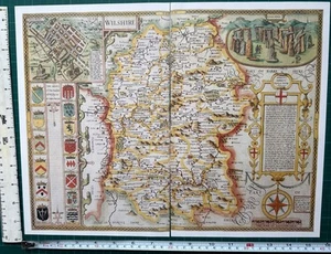
Old Antique Tudor map Wiltshire, Salisbury, England Speed 1600's Reprint
GBP 4.99
ApproximatelyUS $6.70
Condition:
“This map is a book plate taken very carefully from a book of maps printed in 1988. It is printed on ”... Read moreabout condition
- Buy It NowOld Antique Tudor map Wiltshire, Salisbury, England Speed 1600's Reprint
Oops! Looks like we're having trouble connecting to our server.
Refresh your browser window to try again.
Shipping:
GBP 15.50 (approx US $20.80) International Priority Shipping to United States via eBay's Global Shipping Program.
Located in: Sheffield, United Kingdom
Import charges:
Free amount confirmed at checkout
Delivery:
Estimated between Mon, Jul 28 and Wed, Aug 6 to 91768
Includes international tracking
Returns:
Seller does not accept returns.
Payments:
Earn up to 5x points when you use your eBay Mastercard®. Learn moreabout earning points with eBay Mastercard
Shop with confidence
Seller assumes all responsibility for this listing.
eBay item number:306259296737
Item specifics
- Seller Notes
- Antique
- Yes
- Date Range
- 1600-1699
- Type
- County Map
- Format
- Wall/ Poster Map
- Year
- 1610
- Era
- 1600s
- Cartographer/Publisher
- John Speed
- Original/Reproduction
- Antique Reproduction
- Country/Region
- England
- County
- Wiltshire
- Map Type
- Countries/ Borders
- Antique/ Modern
- Antique
Item description from the seller
Seller feedback (3,313)
- *****- Feedback left by buyer.Past monthVerified purchaseExcellent transaction. Map was as described, well packaged and delivered on time Recommended seller
- *****- Feedback left by buyer.Past 6 monthsVerified purchaseAs described. Well protected with cardboard in envelope for international mail England to Australia. Seller recommended. Thanks A+
- *****- Feedback left by buyer.Past 6 monthsVerified purchaseItem exactly as described, quick dispatch and delivery. Overall, excellent service from this highly recommended seller.Buy with 100% confidence !
This is a private listing and your identity will not be disclosed to anyone except the seller.
More to explore :
- Antique European Maps & Atlases England Wiltshire,
- Antique European Maps & Atlases Wiltshire,
- England European Antique Maps & Atlases Wiltshire 1800-1899 Date Range,
- Wiltshire Antique Original Antique European Maps & Atlases,
- Antique European Maps & Atlases England 1600-1699 Date Range,
- England Antique Europe Maps & Atlases,
- England Antique Europe Folding Maps,
- England Copper Plate Maps & Atlases European Antique 1600-1699 Date Range,
- London England Antique Europe Folding Maps,
- Antique European Maps & Atlases Dover England