
ANTIQUE MAP BEDFORD SHOWING BOUNDARY OF BOROUGH C1835 PUB. C LEWIS ENG WALKER
GBP 8.50GBP 8.50
Sun, Apr 27, 12:33 PMSun, Apr 27, 12:33 PM
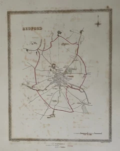


ANTIQUE MAP BEDFORD SHOWING BOUNDARY OF BOROUGH C1835 PUB. C LEWIS ENG WALKER
Condition:
Ended: Apr 27, 2025 12:33:26 PDT
Oops! Looks like we're having trouble connecting to our server.
Refresh your browser window to try again.
Shipping:
GBP 5.50 (approx US $7.45) Royal Mail International Standard.
International shipment of items may be subject to customs processing and additional charges.
Located in: Llanelli, United Kingdom
Delivery:
Estimated between Wed, Jun 11 and Wed, Jun 25 to 94104
Returns:
Seller does not accept returns.
Payments:
Earn up to 5x points when you use your eBay Mastercard®. Learn moreabout earning points with eBay Mastercard
Shop with confidence
Seller assumes all responsibility for this listing.
eBay item number:316689778368
Item specifics
- Year
- 1835
- Antique
- Yes
- Date Range
- 1800-1899
- Type
- City Map
- Format
- Sheet Map
- Printing Technique
- Copper Plate
- Original/Reproduction
- Antique Original
- Cartographer/Publisher
- LEWIS
- City
- BEDFORD
- County
- Bedfordshire
Item description from the seller
Seller Feedback
No feedback yet
More to explore :
- Antique Pub Tables,
- Pub Table Antique Tables,
- Iron Antique Pub Tables,
- Original Antique Pub Tables,
- Oak Antique Pub Tables,
- English Pub Table Antique Tables,
- Antique Atlas Maps,
- Antique Original Political Map Antique Sheet Maps,
- Antique Maps, Atlases & Globes,
- Antique Original Railroad Map Antique Folding Maps