
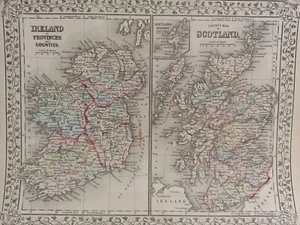
1873 Mitchell's Atlas County Map of Ireland and Scotland Authentic Hand-colored
US $100.00US $100.00
Mon, Apr 28, 06:31 AMMon, Apr 28, 06:31 AM
Picture 1 of 8


Gallery
Picture 1 of 8


Have one to sell?
1873 Mitchell's Atlas County Map of Ireland and Scotland Authentic Hand-colored
US $100.00
or Best Offer
Condition:
“Very good condition. Some slight Brown stain in the St. Georges Channel (Ireland half) and a minute ”... Read moreabout condition
Oops! Looks like we're having trouble connecting to our server.
Refresh your browser window to try again.
Shipping:
US $11.95 Economy Shipping.
Located in: Swampscott, Massachusetts, United States
Delivery:
Estimated between Fri, Aug 1 and Fri, Aug 8 to 94104
Returns:
30 days returns. Buyer pays for return shipping. If you use an eBay shipping label, it will be deducted from your refund amount.
Payments:
.
Special financing available. See terms and apply now- for PayPal Credit, opens in a new window or tab
Earn up to 5x points when you use your eBay Mastercard®. Learn moreabout earning points with eBay Mastercard
Shop with confidence
Seller assumes all responsibility for this listing.
eBay item number:326123130615
Item specifics
- Seller Notes
- Type
- County Map
- Format
- Atlas Map
- Year
- 1873
- Date Range
- 1800-1899
- Printing Technique
- Lithography
- Cartographer/Publisher
- Samuel Augustus Mitchell
- Original/Reproduction
- Antique Original
- Country/Region
- Ireland, Scotland
Item description from the seller
Seller Feedback
No feedback yet
More to explore :
- Ireland County Map Antique Europe Atlas Maps,
- Scotland Antique Europe County Maps,
- Ireland Antique Europe County Maps,
- County Map Antique Atlas Maps,
- County Map Antique Atlas,
- Ireland Lithography Antique Europe County Maps,
- Lithography County Map Antique Atlas,
- County Map Reproduction Antique Atlas,
- Scotland Antique Original Antique Europe County Maps,
- Antique Original County Map Antique Atlas Maps