
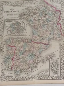
1873 Mitchell's Atlas Map of France, Spain and Portugal Authentic Hand-colored
US $100.00US $100.00
Mon, Apr 28, 06:32 AMMon, Apr 28, 06:32 AM
Picture 1 of 10


Gallery
Picture 1 of 10


Have one to sell?
1873 Mitchell's Atlas Map of France, Spain and Portugal Authentic Hand-colored
US $100.00
or Best Offer
Condition:
“Very good condition. slight wear and browning, primarily not he edges, one rip extends into the ”... Read moreabout condition
Oops! Looks like we're having trouble connecting to our server.
Refresh your browser window to try again.
Shipping:
US $11.95 Economy Shipping.
Located in: Swampscott, Massachusetts, United States
Delivery:
Estimated between Wed, Jul 30 and Tue, Aug 5 to 94104
Returns:
30 days returns. Buyer pays for return shipping. If you use an eBay shipping label, it will be deducted from your refund amount.
Payments:
.
Special financing available. See terms and apply now- for PayPal Credit, opens in a new window or tab
Earn up to 5x points when you use your eBay Mastercard®. Learn moreabout earning points with eBay Mastercard
Shop with confidence
Seller assumes all responsibility for this listing.
eBay item number:326123131046
Item specifics
- Seller Notes
- Format
- Atlas Map
- Year
- 1873
- Date Range
- 1800-1899
- Type
- Political Map
- Printing Technique
- Lithography
- Cartographer/Publisher
- Samuel Augustus Mitchell
- Original/Reproduction
- Antique Original
- Country/Region
- Portugal, France, Spain
Item description from the seller
Seller Feedback
No feedback yet
More to explore :
- Portugal Antique Europe Atlas Maps,
- Spain Antique Europe Atlas Maps,
- Portugal County Map Antique Europe Atlas Maps,
- Spain Political Map Antique Europe Atlas Maps,
- Portugal Political Map Antique Europe Atlas Maps,
- Spain City Map Antique Europe Atlas Maps,
- France Topographical Map Antique Europe Atlas Maps,
- France County Map Antique Europe Atlas Maps,
- Samuel Augustus Mitchell Copper Plate Antique Atlas Maps,
- Antique Atlas Maps