
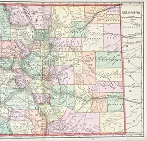
1908 COLORADO Map ORIGINAL (20x13) RAILROADS TOWNSHIPS COUNTIES
US $58.00US $58.00
Wed, May 14, 06:52 PMWed, May 14, 06:52 PM
Picture 1 of 7


Gallery
Picture 1 of 7


Have one to sell?
1908 COLORADO Map ORIGINAL (20x13) RAILROADS TOWNSHIPS COUNTIES
US $58.00
or Best Offer
Condition:
Oops! Looks like we're having trouble connecting to our server.
Refresh your browser window to try again.
Shipping:
Free USPS Ground Advantage®.
Located in: Monroe, Georgia, United States
Delivery:
Estimated between Mon, Jul 28 and Mon, Aug 4 to 94104
Returns:
30 days returns. Seller pays for return shipping.
Payments:
.
Special financing available. See terms and apply now- for PayPal Credit, opens in a new window or tab
Earn up to 5x points when you use your eBay Mastercard®. Learn moreabout earning points with eBay Mastercard
Shop with confidence
Seller assumes all responsibility for this listing.
eBay item number:326391894195
Item specifics
- Date Range
- 1900-1909
- Type
- Map
- Format
- Atlas Map
- Printing Technique
- Lithography
- US State
- AZ, CA, CO, NM, NV, UT, Colorado
- Mexican State
- Durango
- Year
- 1908
- Original/Reproduction
- Antique Original
- Cartographer/Publisher
- George Cram
- City
- Denver
- Country/Region
- United States of America
Item description from the seller
Seller Feedback
No feedback yet
More to explore :
- Colorado Antique North America County Maps,
- Antique Original Antique County Maps,
- Antique Original County Map Antique Sheet Maps,
- Vintage Original County Map Antique Atlas Maps,
- Vintage Original Antique County Maps,
- Colorado Antique Original Antique North America Railroad Maps,
- Antique Original Antique Asia County Maps,
- Lithography Antique Original Antique County Maps,
- Antique Original Antique Africa County Maps,
- Antique County Maps