
1887 MISSOURI Map ORIGINAL (12.5 X 10) Townships RAILROADS St Louis
US $38.00US $38.00
Mon, Apr 28, 01:26 PMMon, Apr 28, 01:26 PM
Picture 1 of 4


Gallery
Picture 1 of 4


Have one to sell?
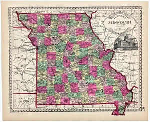
1887 MISSOURI Map ORIGINAL (12.5 X 10) Townships RAILROADS St Louis
US $38.00
or Best Offer
Condition:
Oops! Looks like we're having trouble connecting to our server.
Refresh your browser window to try again.
Shipping:
Free USPS Ground Advantage®.
Located in: Monroe, Georgia, United States
Delivery:
Estimated between Fri, Aug 1 and Thu, Aug 7 to 94104
Returns:
30 days returns. Seller pays for return shipping.
Payments:
.
Special financing available. See terms and apply now- for PayPal Credit, opens in a new window or tab
Earn up to 5x points when you use your eBay Mastercard®. Learn moreabout earning points with eBay Mastercard
Shop with confidence
Seller assumes all responsibility for this listing.
eBay item number:326425967522
Item specifics
- Date Range
- 1800-1899
- Type
- Railroad Map
- US State
- Missouri
- Format
- Atlas Map
- Printing Technique
- Lithography
- Year
- 1887
- Original/Reproduction
- Antique Original
- Cartographer/Publisher
- H.C. TUNISON ATLAS COMPANY
- City
- St. Louis
- Country/Region
- United States of America
Item description from the seller
Seller Feedback
No feedback yet
More to explore :
- St. Louis Missouri Antique North America Railroad Maps,
- St. Louis Missouri Antique Original Antique North American Maps & Atlases,
- St. Louis Missouri Antique North America Maps & Atlases,
- St. Louis Missouri Antique North America County Maps,
- St. Louis Missouri Antique North America City Maps,
- St. Louis Missouri Antique North America Atlas Maps,
- Missouri Antique North America Railroad Maps,
- St. Louis Antique North America City Maps,
- Vintage Original Antique Railroad Maps,
- Missouri Vintage Original Antique North America Topographical Maps