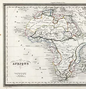


1845 AFRICA Map ORIGINAL (10x7.5) Alexandre Vuillemin EGYPT CAPE COLONY
US $34.00
or Best Offer
Condition:
“GOOD CONDITION- DISCOLORATION, SLIT/TEAR AT RIGHT BORDER REPAIRED ON REVERSE WITH ARCHIVAL TAPE”
Oops! Looks like we're having trouble connecting to our server.
Refresh your browser window to try again.
Shipping:
Free USPS Ground Advantage®.
Located in: Monroe, Georgia, United States
Delivery:
Estimated between Fri, May 23 and Fri, May 30 to 43230
Returns:
30 days returns. Seller pays for return shipping.
Payments:
Special financing available. See terms and apply now- for PayPal Credit, opens in a new window or tab
Earn up to 5x points when you use your eBay Mastercard®. Learn moreabout earning points with eBay Mastercard
Shop with confidence
Seller assumes all responsibility for this listing.
eBay item number:326531775320
Item specifics
- Seller Notes
- “GOOD CONDITION- DISCOLORATION, SLIT/TEAR AT RIGHT BORDER REPAIRED ON REVERSE WITH ARCHIVAL TAPE”
- Date Range
- 1800-1899
- Type
- Political Map
- Format
- Atlas Map
- Printing Technique
- Copper Plate
- Year
- 1845
- Original/Reproduction
- Antique Original
- Cartographer/Publisher
- Alexandre Vuillemin
- City
- Cairo
- Country/Region
- Algeria, Burkina Faso, Central African Republic, Egypt, Equatorial Guinea, Guinea, Morocco, Somalia, South Africa, Tripoli
Item description from the seller
Seller Feedback
No feedback yet
More to explore :
- Cape Verde Copper Plate Antique Africa Maps & Atlases,
- Antique Original Antique Africa County Maps,
- Antique Original Antique Africa Political Maps,
- Antique Original Topographical Map Antique Africa Atlas Maps,
- Antique Original Antique Africa City Maps,
- Antique Original Antique Africa Folding Maps,
- Vintage Original Antique Africa Maps & Atlases,
- Antique Original Antique Africa Topographical Maps,
- Ethiopia Antique Original Antique Africa Maps & Atlases,
- Algiers Antique Original Antique Africa Maps & Atlases