


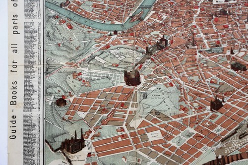


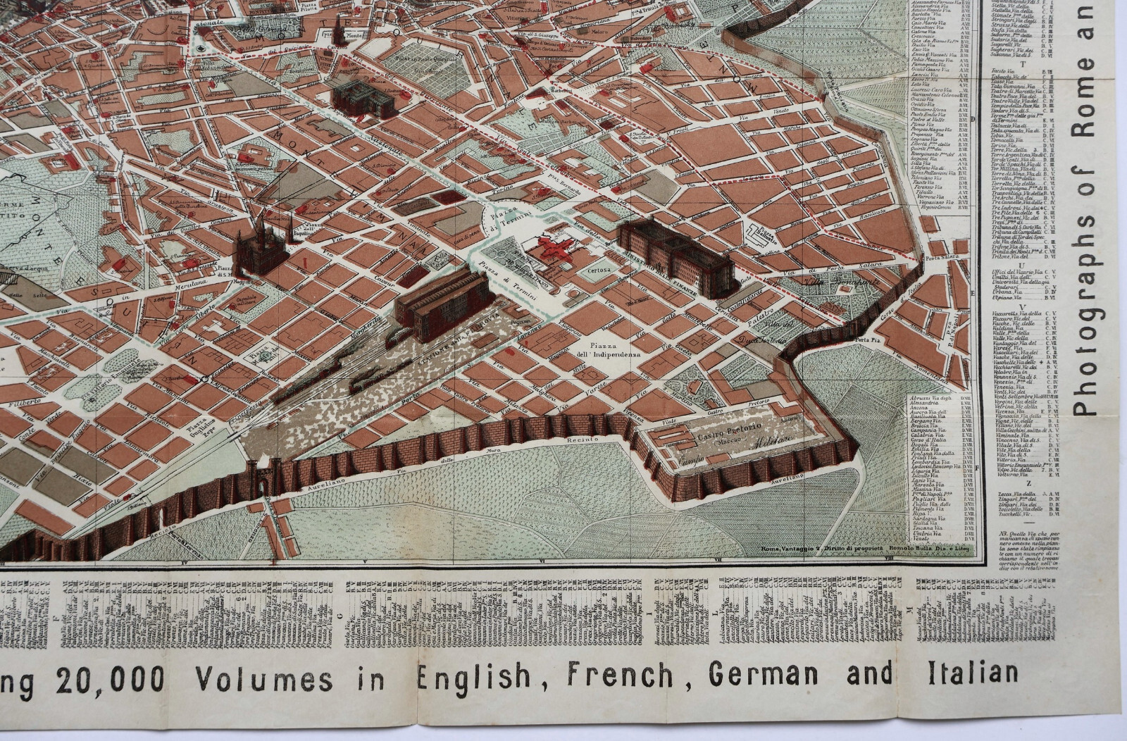


Antique Map "Pianta Guida della Città di Roma" R. Bulla, 1885
GBP 325.00
ApproximatelyUS $440.51
or Best Offer
Condition:
- Buy It NowAntique Map "Pianta Guida della Città di Roma" R. Bulla, 1885
Oops! Looks like we're having trouble connecting to our server.
Refresh your browser window to try again.
Shipping:
GBP 18.00 (approx US $24.40) Royal Mail International Tracked.
International shipment of items may be subject to customs processing and additional charges.
Located in: London, United Kingdom
Delivery:
Estimated between Thu, Jun 12 and Sat, Jun 21 to 94104
Returns:
Seller does not accept returns.
Payments:
Earn up to 5x points when you use your eBay Mastercard®. Learn moreabout earning points with eBay Mastercard
Shop with confidence
Seller assumes all responsibility for this listing.
eBay item number:335288913799
Item specifics
- Date Range
- 1800-1899
- Antique
- Yes
- Type
- City Map
- Format
- Folding Map
- Printing Technique
- Lithography
- Year
- 1885
- Era
- 1800s
- Original/Reproduction
- Antique Original
- Cartographer/Publisher
- Romolo Bulla
- City
- Rome
- Country/Region
- Italy
- County
- Rome
Item description from the seller

Popular categories from this store
Seller feedback (276)
- e***2 (1281)- Feedback left by buyer.Past monthVerified purchaseExquisite 18th century depiction and gravure of the legendary Bastille by one of the greatest artists of the period and the engraver. Offered at a price point which was generous and more than affordable. This gravure was professionally, expertly packaged—which is a distinct pleasure. It is always pleasing to deal with a professional business in antiquities, as they possess the knowledge in handling fragile, irreplaceable, historical art. Sent securely by Fedex, arriving very quickly. Recommended
- f***5 (5)- Feedback left by buyer.Past 6 monthsVerified purchaseThe package was sent quickly and securely with protection for the maps on all sides. An authenticity letter was also placed with the map. It is in the condition as described and displayed (really good). I would definitely purchase from this seller again. Thank you.Antique Map "Tarawera District, New Zealand" Royal Geographical Society, 1886 (#335450217107)
- u***i (148)- Feedback left by buyer.Past 6 monthsVerified purchaseItem as described. Packed well with fast shipping. In good condition for its age! Would buy from this seller again.
More to explore :
- Antique Atlas Maps,
- Antique Original Political Map Antique Sheet Maps,
- Antique Original River Map Antique Folding Maps,
- Antique Original Nautical Map Antique Folding Maps,
- Antique Original County Map Antique Wall Maps,
- Antique Maps, Atlases & Globes,
- Antique Original City Map Antique Atlas Maps,
- Antique Original City Map Antique Wall Maps,
- Antique Original County Map Antique Folding Maps,
- Antique Original Topographical Map Antique Sheet Maps
Popular categories from this store
Seller feedback (276)
- e***2 (1281)- Feedback left by buyer.Past monthVerified purchaseExquisite 18th century depiction and gravure of the legendary Bastille by one of the greatest artists of the period and the engraver. Offered at a price point which was generous and more than affordable. This gravure was professionally, expertly packaged—which is a distinct pleasure. It is always pleasing to deal with a professional business in antiquities, as they possess the knowledge in handling fragile, irreplaceable, historical art. Sent securely by Fedex, arriving very quickly. Recommended
- f***5 (5)- Feedback left by buyer.Past 6 monthsVerified purchaseThe package was sent quickly and securely with protection for the maps on all sides. An authenticity letter was also placed with the map. It is in the condition as described and displayed (really good). I would definitely purchase from this seller again. Thank you.Antique Map "Tarawera District, New Zealand" Royal Geographical Society, 1886 (#335450217107)
- u***i (148)- Feedback left by buyer.Past 6 monthsVerified purchaseItem as described. Packed well with fast shipping. In good condition for its age! Would buy from this seller again.