
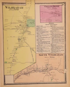
1870 Plat Map ~ WILBRAHAM, HAMPDEN Co., MASSACHUSETTS / COLLINS DEPOT (12x15)#22
US $48.88US $48.88
Sun, Jul 06, 10:10 AMSun, Jul 06, 10:10 AM
Picture 1 of 1
Gallery
Picture 1 of 1

Have one to sell?
1870 Plat Map ~ WILBRAHAM, HAMPDEN Co., MASSACHUSETTS / COLLINS DEPOT (12x15)#22
US $48.88
or Best Offer
Condition:
“This map is not *new* or in *new* condition. It was removed from an 1870 Hampden County, ”... Read moreabout condition
Oops! Looks like we're having trouble connecting to our server.
Refresh your browser window to try again.
Shipping:
Free USPS Ground Advantage®.
Located in: Schertz, Texas, United States
Delivery:
Estimated between Fri, Jul 25 and Fri, Aug 1 to 94104
Returns:
30 days returns. Buyer pays for return shipping. If you use an eBay shipping label, it will be deducted from your refund amount.
Payments:
.
Special financing available. See terms and apply now- for PayPal Credit, opens in a new window or tab
Earn up to 5x points when you use your eBay Mastercard®. Learn moreabout earning points with eBay Mastercard
Shop with confidence
Seller assumes all responsibility for this listing.
eBay item number:356442234902
Item specifics
- Seller Notes
- Date Range
- 1800-1899
- Type
- Plat Atlas Map
- Printing Technique
- Hand Tinted
- Format
- Atlas Map
- US State
- Massachusetts
- Year
- 1870
- Color
- All colors are original.
- Original/Reproduction
- Antique Original
- Cartographer/Publisher
- F. W. Beers
- Country/Region
- United States of America
- Original
- This map page was printed in 1870.
Item description from the seller
Seller Feedback
No feedback yet
More to explore :
- Massachusetts Rand McNally & Co. Antique North America Maps & Atlases,
- Massachusetts County Map Antique North America Atlas Maps,
- Massachusetts Topographical Map Antique North America Sheet Maps,
- Massachusetts Antique North America Railroad Maps,
- Massachusetts Antique North America Sheet Maps,
- Massachusetts City Map Antique North America Atlas Maps,
- Massachusetts Antique North America County Maps,
- Massachusetts Antique North America City Maps,
- Massachusetts Antique North America Topographical Maps,
- Massachusetts County Map Antique North America Atlas