
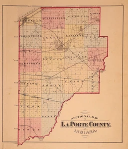
1874 Plat / County Map ~ LaPorte County, Indiana ~ (14x17)-#01
US $45.95US $45.95
Tue, Apr 29, 07:30 AMTue, Apr 29, 07:30 AM
Picture 1 of 2

Gallery
Picture 1 of 2


Have one to sell?
1874 Plat / County Map ~ LaPorte County, Indiana ~ (14x17)-#01

US $45.95
or Best Offer
Was US $48.88 (6% off)
Condition:
“This map is not *new* or in *new* condition. It was removed from an 1874 LaPorte County, Indiana ”... Read moreabout condition
Ended: Apr 29, 2025 07:30:02 PDT
Oops! Looks like we're having trouble connecting to our server.
Refresh your browser window to try again.
Shipping:
Free USPS Ground Advantage®.
Located in: San Antonio, Texas, United States
Delivery:
Estimated between Fri, Jul 25 and Thu, Jul 31 to 94104
Returns:
30 days returns. Buyer pays for return shipping. If you use an eBay shipping label, it will be deducted from your refund amount.
Payments:
.
Special financing available. See terms and apply now- for PayPal Credit, opens in a new window or tab
Earn up to 5x points when you use your eBay Mastercard®. Learn moreabout earning points with eBay Mastercard
Shop with confidence
Seller assumes all responsibility for this listing.
eBay item number:356532613466
Item specifics
- Seller Notes
- Format
- Plat Atlas Map
- US State
- Indiana
- Year
- 1874
- Size
- 14" x 17"
- Color
- Original Hand Tinting
- Packaging
- All maps are shipped in a secure water-resistant mailing tube
- Original/Reproduction
- Antique Original
- Cartographer/Publisher
- Higgins , Belden & Co.
- Shipping
- Free S&H USA - Calculated S&H Worldwide
Item description from the seller

Seller feedback (9,604)
- 1***l (18)- Feedback left by buyer.Past 6 monthsVerified purchaseFinally! The "ancestral plat map" arrived and is well worth the long wait!. It is as nice or even nicer than what the seller described. It was packaged adequately, I don't know why it took from 11 April to 5 May to be delivered, but I suspect this was outside the control/responsibility of the seller. I am grateful that this irreplaceable old document was not forever "lost in the mail." Thank you, thank you, thank you!1872 Plat Map ~ FENTON Twp., WHITESIDE Co., ILLINOIS - (15x18)-#10 (#405722860174)
- t***i (1204)- Feedback left by buyer.Past monthVerified purchasefast shipping...expertly packaged...received as shown/described...great communication...no issues...awesome seller!
- a***z (871)- Feedback left by buyer.Past 6 monthsVerified purchaseOutstanding transaction: Great communication; prompt shipping; secure packaging. Item as shown and described on ebay. Highly recommend MapHatter shop to all ebay buyers!!
More to explore :
- Indiana Antique North America County Maps,
- Antique County Maps,
- Indiana County Map Antique North America Folding Maps,
- Indiana County Map Antique North America Atlas Maps,
- Washington Indiana Antique North America County Maps,
- Lithography Indiana Antique North America County Maps,
- Antique Europe County Maps,
- Lithography Antique County Maps,
- County Map Antique Europe Folding Maps,
- County Map Antique World Folding Maps
Seller feedback (9,604)
- 1***l (18)- Feedback left by buyer.Past 6 monthsVerified purchaseFinally! The "ancestral plat map" arrived and is well worth the long wait!. It is as nice or even nicer than what the seller described. It was packaged adequately, I don't know why it took from 11 April to 5 May to be delivered, but I suspect this was outside the control/responsibility of the seller. I am grateful that this irreplaceable old document was not forever "lost in the mail." Thank you, thank you, thank you!1872 Plat Map ~ FENTON Twp., WHITESIDE Co., ILLINOIS - (15x18)-#10 (#405722860174)
- t***i (1204)- Feedback left by buyer.Past monthVerified purchasefast shipping...expertly packaged...received as shown/described...great communication...no issues...awesome seller!
- a***z (871)- Feedback left by buyer.Past 6 monthsVerified purchaseOutstanding transaction: Great communication; prompt shipping; secure packaging. Item as shown and described on ebay. Highly recommend MapHatter shop to all ebay buyers!!