
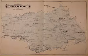
1877 Plat Map ~ 10th District, BALTIMORE Co., MARYLAND / MONKTON (17x26)-#10
US $64.75US $64.75
Tue, Jul 15, 09:48 AMTue, Jul 15, 09:48 AM
Picture 1 of 3


Gallery
Picture 1 of 3


Have one to sell?
1877 Plat Map ~ 10th District, BALTIMORE Co., MARYLAND / MONKTON (17x26)-#10
US $64.75
or Best Offer
Was US $68.88 (6% off)
Condition:
“This map is not *new* or in *new* condition. It was removed from an 1877 Baltimore County, Maryland ”... Read moreabout condition
Ended: Jul 15, 2025 09:48:46 PDT
Oops! Looks like we're having trouble connecting to our server.
Refresh your browser window to try again.
Shipping:
Free USPS Ground Advantage®.
Located in: San Antonio, Texas, United States
Delivery:
Estimated between Fri, Aug 1 and Thu, Aug 7 to 94104
Returns:
30 days returns. Buyer pays for return shipping. If you use an eBay shipping label, it will be deducted from your refund amount.
Payments:
.
Special financing available. See terms and apply now- for PayPal Credit, opens in a new window or tab
Earn up to 5x points when you use your eBay Mastercard®. Learn moreabout earning points with eBay Mastercard
Shop with confidence
Seller assumes all responsibility for this listing.
eBay item number:356784538415
Item specifics
- Seller Notes
- US State
- Maryland
- Size
- 17" x 23"
- Color
- Original Hand Tinting
- Cartographer/Publisher
- G. M. Hopkins C.E.
- Date Range
- 1800-1899
- Type
- District / Township Map
- Format
- Atlas Map
- Title page
- The book cover and title page are not included in the sale.
- Year
- 1877
- Packaging
- All maps are shipped in a secure water-resistant mailing tube
- Original/Reproduction
- Antique Original
- Ancestry
- Landowners' names - Property boundaries - Family History
- Shipping
- Free S&H USA - Calculated S&H Worldwide
- Country/Region
- United States of America
Item description from the seller
Seller Feedback
No feedback yet
More to explore :
- District of Columbia Maryland Antique North America Maps & Atlases,
- Baltimore Maryland Antique North America County Maps,
- Baltimore Maryland Antique North America Atlas Maps,
- Baltimore Maryland Antique North American Maps & Atlases,
- Baltimore Maryland Antique North America City Maps,
- Baltimore Maryland Antique North America Maps & Atlases 1900-1909 Date Range,
- Maryland City Map Antique North America Atlas Maps,
- Maryland Antique North America Geological Maps,
- District of Columbia Antique North America Atlas Maps,
- Maryland Antique North America Sheet Maps