
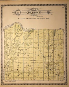
1910 Plat Map ~ CINCINNATI Twp., TAZEWELL Co., Illinois (15x17)-#005
US $28.00US $28.00
Tue, Apr 29, 02:23 PMTue, Apr 29, 02:23 PM


1910 Plat Map ~ CINCINNATI Twp., TAZEWELL Co., Illinois (15x17)-#005
US $28.00
Ends in
Condition:
“This map is not *new* or *new* condition. It was removed from a Plat Atlas and printed in 1910. ”... Read moreabout condition
Ended: Apr 29, 2025 14:23:00 PDT
Oops! Looks like we're having trouble connecting to our server.
Refresh your browser window to try again.
Shipping:
Free USPS Ground Advantage®.
Located in: Schertz, Texas, United States
Delivery:
Estimated between Wed, Jun 25 and Tue, Jul 1 to 91768
Returns:
30 days returns. Buyer pays for return shipping. If you use an eBay shipping label, it will be deducted from your refund amount.
Payments:
Special financing available. See terms and apply now- for PayPal Credit, opens in a new window or tab
Earn up to 5x points when you use your eBay Mastercard®. Learn moreabout earning points with eBay Mastercard
Shop with confidence
Seller assumes all responsibility for this listing.
eBay item number:356805652723
Item specifics
- Seller Notes
- Format
- Plat Atlas Map
- US State
- Illinois
- Year
- 1910
- S&H
- Free S&H USA - Calculated S&H Worldwide
- SIZE
- The page is 15x17
- Cartographer/Publisher
- Geo. A. Ogle & Co.
- Original/Reproduction
- Antique Original
- Land Owners
- Great for ancestry, genealogy & family history research
- Original
- This map page was printed in 1910.
- Ref.
- The title page is not included, it is only for reference.
- County
- Plat Map
- Age
- Over 110 years old.
Item description from the seller
Seller Feedback
No feedback yet
More to explore :
- Illinois Antique North America Maps & Atlases 1910-1919 Date Range,
- Illinois 1910-1919 Date Range Antique North America Topographical Maps,
- Illinois 1910-1919 Date Range Antique North America County Maps,
- Illinois 1910-1919 Date Range Antique North America Sheet Maps,
- Illinois 1910-1919 Date Range Antique North America Folding Maps,
- Illinois County Map Antique North America Atlas Maps,
- Antique North American Maps & Atlases Illinois,
- Illinois Antique North America River Maps,
- Illinois Antique North America Topographical Maps,
- Illinois Antique North America Geological Maps