
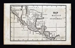
1830 Nathan Hale Map Mexico United States Texas New Albion California Yucatan
US $79.20US $79.20
Sun, Jul 06, 03:30 PMSun, Jul 06, 03:30 PM
Picture 1 of 3


Gallery
Picture 1 of 3


Have one to sell?
1830 Nathan Hale Map Mexico United States Texas New Albion California Yucatan
US $79.20
or Best Offer
Was US $99.00 (20% off)
Condition:
“Fair to Good, it measures approximately 3 3/4 by 6 inches on a 4 1/2 by 7 1/4" page (11x18cm), ”... Read moreabout condition
Ended: Jul 06, 2025 15:30:16 PDT
Oops! Looks like we're having trouble connecting to our server.
Refresh your browser window to try again.
Shipping:
US $4.99 USPS Ground Advantage®.
Located in: Fairview, Pennsylvania, United States
Delivery:
Estimated between Sat, Aug 2 and Sat, Aug 9 to 94104
Returns:
30 days returns. Seller pays for return shipping.
Payments:
.
Special financing available. See terms and apply now- for PayPal Credit, opens in a new window or tab
Earn up to 5x points when you use your eBay Mastercard®. Learn moreabout earning points with eBay Mastercard
Shop with confidence
Seller assumes all responsibility for this listing.
eBay item number:365186948199
Item specifics
- Seller Notes
- Cartographer/Publisher
- Nathan Hale
- Mexican State
- Aguascalientes, Baja California, Campeche, Chiapas, Chihuahua, Coahuila, Colima, Durango, Guanajuato, Yucatán
- Printing Technique
- Copper Plate
- Original/Reproduction
- Antique Original
- Format
- Atlas Map
- Type
- Political Map
- Year
- 1830
- US State
- Arizona, AZ, CA, CO, NM, NV, UT, California, Nevada, New Mexico, OK, TX, Texas
- Date Range
- 1800-1899
- City
- San Francisco
- Country/Region
- Mexico
Item description from the seller
Seller Feedback
No feedback yet
More to explore :
- United States of America New Mexico Antique North America Topographical Maps,
- United States of America New Mexico Antique North America Maps & Atlases,
- United States of America New Mexico Antique North America Atlas Maps,
- United States of America New Mexico Antique North America Sheet Maps,
- Mexico Texas Antique North American Maps & Atlases,
- Mexico New Mexico Antique North America Maps & Atlases,
- United States of America Texas Antique North America County Maps,
- United States of America California Antique North America Maps & Atlases,
- New Mexico Antique North America Maps & Atlases,
- New Mexico Topographical Map Antique North America Sheet Maps