
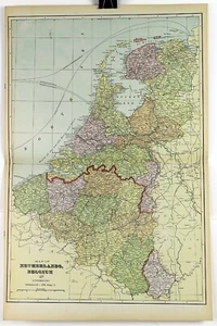
1890s Map of Netherlands and Belgium Full Color Lithography 14.25 x 21.75
US $61.85US $61.85
Sun, Jun 22, 07:03 AMSun, Jun 22, 07:03 AM


1890s Map of Netherlands and Belgium Full Color Lithography 14.25 x 21.75
US $61.85
or Best Offer
Condition:
“See photos for condition description. Pictures are of the actual item(s) you will receive.”
Oops! Looks like we're having trouble connecting to our server.
Refresh your browser window to try again.
Shipping:
US $12.25 USPS Priority Mail®.
Located in: Belton, Missouri, United States
Delivery:
Estimated between Tue, Jul 8 and Mon, Jul 14 to 94104
Returns:
30 days returns. Buyer pays for return shipping. If you use an eBay shipping label, it will be deducted from your refund amount.
Payments:
.
Special financing available. See terms and apply now- for PayPal Credit, opens in a new window or tab
Earn up to 5x points when you use your eBay Mastercard®. Learn moreabout earning points with eBay Mastercard
Shop with confidence
Seller assumes all responsibility for this listing.
eBay item number:376193793220
Item specifics
- Seller Notes
- “See photos for condition description. Pictures are of the actual item(s) you will receive.”
- Date Range
- 1800-1899
- Type
- Physical Map
- Format
- Atlas Map
- Printing Technique
- Lithography
- Map View
- World
- Original/Reproduction
- Antique Original
- Cartographer/Publisher
- George Cram
Item description from the seller
Seller Feedback
No feedback yet
More to explore :
- Belgium Lithography Antique Europe Sheet Maps,
- Antique European Maps & Atlases Belgium Lithography,
- Belgium Lithography Antique Europe Atlas Maps,
- Netherlands Lithography Antique Europe City Maps,
- Antique European Maps & Atlases Netherlands Lithography,
- Netherlands Lithography Antique Europe Sheet Maps,
- Belgium Lithography 1910-1919 Date Range Antique Europe Maps & Atlases,
- Antique European Maps & Atlases Netherlands,
- Lithography Political Map Antique Wall Maps,
- Lithography Railroad Map Antique Sheet Maps