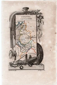

1823 A. M. Perrot Antique Map, Cheshire, Chester, Lancashire, Lancaster, England

AU $75.00
ApproximatelyUS $48.39
or Best Offer
Condition:
“Age toning to page can be seen. As with all old maps/prints there may be minor imperfections, age ”... Read moreabout condition
- Buy It Now1823 A. M. Perrot Antique Map, Cheshire, Chester, Lancashire, Lancaster, England
Oops! Looks like we're having trouble connecting to our server.
Refresh your browser window to try again.
Shipping:
AU $20.00 (approx US $12.90) International Standard : tracked-signature (7 to 15 business days).
International shipment of items may be subject to customs processing and additional charges.
Located in: Surfers Paradise, QLD, Australia
Delivery:
Estimated between Mon, Jun 30 and Tue, Jul 8 to 94104
Returns:
Seller does not accept returns.
Payments:
Earn up to 5x points when you use your eBay Mastercard®. Learn moreabout earning points with eBay Mastercard
Shop with confidence
Seller assumes all responsibility for this listing.
eBay item number:385660644043
Item specifics
- Seller Notes
- Date Range
- 1800-1899
- Type
- County Map
- Format
- Atlas Map
- Printing Technique
- Copper Plate
- Year
- 1823
- Original/Reproduction
- Antique Original
- Cartographer/Publisher
- Perrot
- Region of Origin
- Europe
- Country/Region
- England
- County
- Cheshire
Item description from the seller

Seller feedback (96)
- *****- Feedback left by buyer.Past 6 monthsVerified purchaseItem arrived quickly and exactly as described. Great seller — smooth transaction and excellent communication. Highly recommend!
- *****- Feedback left by buyer.Past 6 monthsVerified purchaseBeautiful print as described, worth the cost and packaged well to protect through shipping. Fast postage for our rural location and would happily buy from this seller again.
- *****- Feedback left by buyer.Past 6 monthsVerified purchaseMy map arrived quickly and was very well packaged. I was really happy with the seller and transaction. I would definitely do business with them again. A+!
This is a private listing and your identity will not be disclosed to anyone except the seller.
More to explore :
- Antique European Maps & Atlases England Lancashire,
- Antique European Maps & Atlases England Cheshire,
- England European Antique Maps & Atlases Lancashire 1800-1899 Date Range,
- Antique European Maps & Atlases Lancashire,
- England European Antique Maps & Atlases Cheshire 1800-1899 Date Range,
- England Antique Europe Maps & Atlases,
- England County Map Antique Europe Atlas Maps,
- London England Antique Europe Folding Maps,
- Antique European Maps & Atlases England Warwickshire,
- Antique European Maps & Atlases Dover England
Seller feedback (96)
- *****- Feedback left by buyer.Past 6 monthsVerified purchaseItem arrived quickly and exactly as described. Great seller — smooth transaction and excellent communication. Highly recommend!
- *****- Feedback left by buyer.Past 6 monthsVerified purchaseBeautiful print as described, worth the cost and packaged well to protect through shipping. Fast postage for our rural location and would happily buy from this seller again.
- *****- Feedback left by buyer.Past 6 monthsVerified purchaseMy map arrived quickly and was very well packaged. I was really happy with the seller and transaction. I would definitely do business with them again. A+!