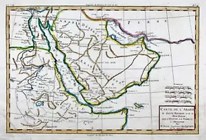


1780 Bonne, map of Middle East, Persia, Red Sea, Egypt, Nubia hand coloured

GBP 115.00
ApproximatelyUS $157.73
or Best Offer
Condition:
“Original Antique Map”
- Buy It Now1780 Bonne, map of Middle East, Persia, Red Sea, Egypt, Nubia hand coloured
Oops! Looks like we're having trouble connecting to our server.
Refresh your browser window to try again.
Shipping:
GBP 16.00 (approx US $21.95) International Tracked Postage.
International shipment of items may be subject to customs processing and additional charges.
Located in: Norwich, United Kingdom
Delivery:
Estimated between Mon, Jul 7 and Wed, Jul 16 to 94104
Returns:
30 days returns. Buyer pays for return shipping. If you use an eBay shipping label, it will be deducted from your refund amount.
Payments:
Earn up to 5x points when you use your eBay Mastercard®. Learn moreabout earning points with eBay Mastercard
Shop with confidence
Seller assumes all responsibility for this listing.
eBay item number:403928767206
Item specifics
- Seller Notes
- “Original Antique Map”
- Date Range
- 1700-1799
- Original/Reproduction
- Antique Original
- Printing Technique
- Copper Plate
- Type
- Topographical Map
- Cartographer/Publisher
- Bonne
- Year
- 1780
- Country/Region
- Egypt, Eritrea, Ethiopia, Tunisia
Item description from the seller

Seller feedback (50,813)
- _***p (3027)- Feedback left by buyer.Past 6 monthsVerified purchaseThe item was delivered promptly and securely packaged. It arrived in the exact condition as described. The service provided was excellent, reflecting the seller's professionalism and attention to detail. Overall, a highly satisfactory and worthwhile purchase Good Value.
- e***s (184)- Feedback left by buyer.Past 6 monthsVerified purchaseExcellent seller. Very good communication. Item was well priced, arrived quickly, as described and very well packaged. Highly recommended!1719 Celestial chart, Planet Mercury, Mallet, hand coloured, astronomy, map (#405535197410)
- _***o (888)- Feedback left by buyer.Past 6 monthsVerified purchaseNice item, good price, active communication, well-packaged, timely overseas shipping. Thanks!1824 Dolphins, mammals, K.J. Brodtmann, hand coloured folio lithograph (#176122185821)
More to explore :
- Middle East Antique Asia Maps & Atlases,
- Middle East Antique Asia Atlas Maps,
- Middle East Antique Asia Folding Maps,
- Middle East Antique Original Antique Asia Atlas Maps,
- Middle East Maps & Atlases Asian Antique Original Antique,
- Antique Asian Maps & Atlases Persia,
- Middle East Maps & Atlases Antique Asian 1800-1899 Date Range,
- Middle East Asian Antique Maps & Atlases 1700-1799 Date Range,
- Red Middle Eastern Antiques,
- Manuscript/Hand drawn County Map Antique Sheet Maps
Seller feedback (50,813)
- _***p (3027)- Feedback left by buyer.Past 6 monthsVerified purchaseThe item was delivered promptly and securely packaged. It arrived in the exact condition as described. The service provided was excellent, reflecting the seller's professionalism and attention to detail. Overall, a highly satisfactory and worthwhile purchase Good Value.
- e***s (184)- Feedback left by buyer.Past 6 monthsVerified purchaseExcellent seller. Very good communication. Item was well priced, arrived quickly, as described and very well packaged. Highly recommended!1719 Celestial chart, Planet Mercury, Mallet, hand coloured, astronomy, map (#405535197410)
- _***o (888)- Feedback left by buyer.Past 6 monthsVerified purchaseNice item, good price, active communication, well-packaged, timely overseas shipping. Thanks!1824 Dolphins, mammals, K.J. Brodtmann, hand coloured folio lithograph (#176122185821)