
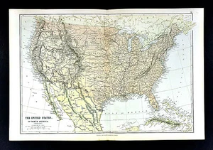
1883 Blackie Map United States of America Indian Territory Oklahoma Dakota Texas
US $36.00US $36.00
Sat, Jun 21, 07:15 PMSat, Jun 21, 07:15 PM
Picture 1 of 4


Gallery
Picture 1 of 4


Have one to sell?
1883 Blackie Map United States of America Indian Territory Oklahoma Dakota Texas
US $36.00
or Best Offer
Was US $45.00 (20% off)
Condition:
“Very Good Condition”
Ended: Jun 21, 2025 19:15:46 PDT
Oops! Looks like we're having trouble connecting to our server.
Refresh your browser window to try again.
Shipping:
US $4.99 USPS Ground Advantage®.
Located in: Fairview, Pennsylvania, United States
Delivery:
Estimated between Sat, Jul 26 and Fri, Aug 1 to 91768
Returns:
30 days returns. Seller pays for return shipping.
Payments:
.
Special financing available. See terms and apply now- for PayPal Credit, opens in a new window or tab
Earn up to 5x points when you use your eBay Mastercard®. Learn moreabout earning points with eBay Mastercard
Shop with confidence
Seller assumes all responsibility for this listing.
eBay item number:405257256777
Item specifics
- Seller Notes
- “Very Good Condition”
- North America States & Provinces
- Oklahoma,Texas
- Publication Year
- 1883
- Country/Region
- United States of America
- Year
- 1883
- Original/Reproduction
- Antique Original
- US State
- AL, FL, GA, MS, NC, SC, AR, IA, KS, LA, MO, NE, AZ, CA, CO, NM, NV, UT, CT, MA, ME, NH, RI, VT, DC, DE, MD, NJ, NY, PA, ID, OR, WA, IL, IN, MI, OH, WI, MN, MT, ND, SD, WY, OK, TX, Oklahoma, Texas, VA, WV, KY, TN
- Date Range
- 1800-1899
- Type
- Political Map
- Format
- Atlas Map
- City
- Washington
- Cartographer/Publisher
- Blackie
Item description from the seller
Seller Feedback
No feedback yet
More to explore :
- United States of America Oklahoma Antique North America Topographical Maps,
- United States of America Oklahoma Antique North America Maps & Atlases,
- United States of America Texas Antique North America County Maps,
- United States of America Texas Antique North America Folding Maps,
- United States of America Texas Antique North America Railroad Maps,
- United States of America North Dakota Antique North America Atlas Maps,
- United States of America North Dakota Antique North America Folding Maps,
- United States of America Texas Antique North America Maps & Atlases 1920-1929 Date Range,
- United States of America County Map Antique North America Atlas Maps,
- United States of America River Map Antique North America Sheet Maps