
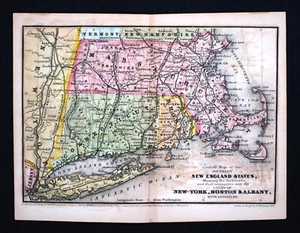


1847 Williams Map New England Massachusetts Connecticut Rhode Island Boston RR
US $80.00
or Best Offer
Was US $100.00 (20% off)
or 4 interest-free payments of $20.00 available with
Condition:
“Good condition with some light back printing, otherwise it has nice original color on a strong page ”... Read moreabout condition
Sale ends in: 4h 47m
- Buy It Now1847 Williams Map New England Massachusetts Connecticut Rhode Island Boston RR
Oops! Looks like we're having trouble connecting to our server.
Refresh your browser window to try again.
Shipping:
US $4.99 USPS Ground Advantage®.
Located in: Fairview, Pennsylvania, United States
Delivery:
Estimated between Tue, May 27 and Mon, Jun 2 to 94104
Returns:
30 days returns. Seller pays for return shipping.
Payments:
.
4 interest-free payments of $20.00 available with Klarna.
Special financing available. See terms and apply now- for PayPal Credit, opens in a new window or tab
Earn up to 5x points when you use your eBay Mastercard®. Learn moreabout earning points with eBay Mastercard
Shop with confidence
Seller assumes all responsibility for this listing.
eBay item number:405257742700
Item specifics
- Seller Notes
- Cartographer/Publisher
- W. Williams
- Printing Technique
- Copper Plate
- Original/Reproduction
- Antique Original
- Format
- Atlas Map
- Topic
- Maps
- Type
- Railroad Map
- Year
- 1847
- US State
- Connecticut, CT, MA, ME, NH, RI, VT, DC, DE, MD, NJ, NY, PA, Massachusetts, New York, Rhode Island
- Date Range
- 1800-1899
- City
- Boston
- Country/Region
- United States of America
Item description from the seller

Popular categories from this store
Seller feedback (19,856)
- l***4 (118)- Feedback left by buyer.Past 6 monthsVerified purchaseVery nice. Received as seller described on their web site. It was well packaged and at a decent cost. Seller was good at communication and is willing to work with the customer.
- u***g (41)- Feedback left by buyer.Past 6 monthsVerified purchaseGreat seller! Packaged safely and shipped quickly. Great communicator and very knowledgeable. Everything showed up exactly as decribed. Incredible value. 12/10 recommend
- 3***d (375)- Feedback left by buyer.Past monthVerified purchaseItem as described, very reasonable price, fast shipping, carefully packaged. Would buy from this seller again
More to explore :
- Boston Rhode Island Antique North America Maps & Atlases,
- Boston Rhode Island Antique Original Antique North American Maps & Atlases,
- Boston Massachusetts Antique North America Atlas Maps,
- Boston Massachusetts Antique North America City Maps,
- Boston Connecticut Antique North American Maps & Atlases,
- Rhode Island County Map Antique North America Atlas Maps,
- Rhode Island Antique North America Railroad Maps,
- Boston Lithography Massachusetts Antique North America Maps & Atlases,
- Newport Rhode Island Antique North America Maps & Atlases,
- George Cram Rhode Island Antique North America Maps & Atlases
Popular categories from this store
Seller feedback (19,856)
- l***4 (118)- Feedback left by buyer.Past 6 monthsVerified purchaseVery nice. Received as seller described on their web site. It was well packaged and at a decent cost. Seller was good at communication and is willing to work with the customer.
- u***g (41)- Feedback left by buyer.Past 6 monthsVerified purchaseGreat seller! Packaged safely and shipped quickly. Great communicator and very knowledgeable. Everything showed up exactly as decribed. Incredible value. 12/10 recommend
- 3***d (375)- Feedback left by buyer.Past monthVerified purchaseItem as described, very reasonable price, fast shipping, carefully packaged. Would buy from this seller again