
1944 Geographical Map Maine Portland Bangor Lewiston Augusta Waterville Caribou
US $15.00US $15.00
Fri, Jul 04, 03:33 PMFri, Jul 04, 03:33 PM
Picture 1 of 1
Gallery
Picture 1 of 1

Have one to sell?
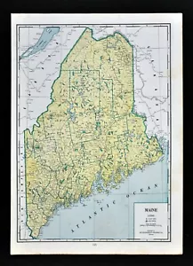
1944 Geographical Map Maine Portland Bangor Lewiston Augusta Waterville Caribou
US $15.00
or Best Offer
Condition:
“Good Condition, on a 10 1/4 by 14 1/2 inch page (26x37cm), see the pics and description below”
Oops! Looks like we're having trouble connecting to our server.
Refresh your browser window to try again.
Shipping:
US $4.99 USPS Ground Advantage®.
Located in: Fairview, Pennsylvania, United States
Delivery:
Estimated between Thu, Jul 31 and Thu, Aug 7 to 94104
Returns:
30 days returns. Seller pays for return shipping.
Payments:
Special financing available. See terms and apply now- for PayPal Credit, opens in a new window or tab
Earn up to 5x points when you use your eBay Mastercard®. Learn moreabout earning points with eBay Mastercard
Shop with confidence
Seller assumes all responsibility for this listing.
eBay item number:405266524807
Item specifics
- Seller Notes
- “Good Condition, on a 10 1/4 by 14 1/2 inch page (26x37cm), see the pics and description below”
- Topic
- United States
- Original/Reproduction
- Antique Original
- Format
- Atlas Map
- Type
- Political Map
- Year
- 1944
- US State
- CT, MA, ME, NH, RI, VT, Maine
- Date Range
- 1940-1949
- City
- Portland
- Country/Region
- United States of America
Item description from the seller
Seller Feedback
No feedback yet
More to explore :
- Maine Antique Nautical Maps,
- Antique North American Maps & Atlases Maine,
- Maine Railroad Map Antique North America Atlas Maps,
- Maine Topographical Map Antique North America Sheet Maps,
- Maine Antique North America City Maps,
- Maine Antique North America Topographical Maps,
- Maine Antique North America County Maps,
- Maine Antique North America River Maps,
- Washington Maine Antique North America County Maps,
- New York Maine American Antique Maps & Atlases