

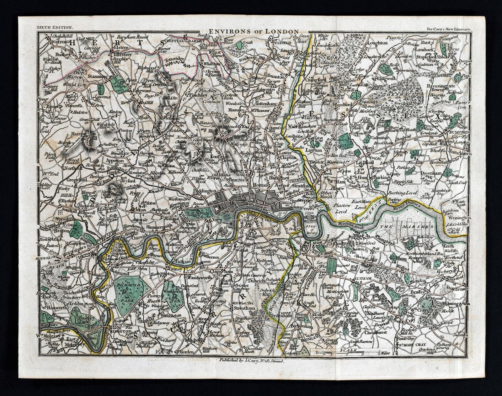

1814 John Cary Road Map London Thames River Kingston Kensington Woolwich England

US $79.99
or Best Offer
or 4 interest-free payments of $20.00 available with
Condition:
“Very Good condition, the map area measures approximately 6 1/2 by 8 1/2" (16x22cm) on a 7 by 9 1/4 ”... Read moreabout condition
- Buy It Now1814 John Cary Road Map London Thames River Kingston Kensington Woolwich England
Oops! Looks like we're having trouble connecting to our server.
Refresh your browser window to try again.
Shipping:
US $4.99 USPS Ground Advantage®.
Located in: Fairview, Pennsylvania, United States
Delivery:
Estimated between Wed, Jul 9 and Mon, Jul 14 to 94104
Returns:
30 days returns. Seller pays for return shipping.
Payments:
.
4 interest-free payments of $20.00 available with Klarna.
Special financing available. See terms and apply now- for PayPal Credit, opens in a new window or tab
Earn up to 5x points when you use your eBay Mastercard®. Learn moreabout earning points with eBay Mastercard
Shop with confidence
Seller assumes all responsibility for this listing.
eBay item number:405275109438
Item specifics
- Seller Notes
- County
- Surrey, Middlesex, Essex
- Cartographer/Publisher
- John Cary
- Printing Technique
- Copper Plate
- Original/Reproduction
- Antique Original
- Format
- Atlas Map
- Type
- County Map
- Year
- 1814
- Date Range
- 1800-1899
- City
- London
- Country/Region
- England
Item description from the seller

Popular categories from this store
Seller feedback (19,883)
- u***g (41)- Feedback left by buyer.Past 6 monthsVerified purchaseGreat seller! Packaged safely and shipped quickly. Great communicator and very knowledgeable. Everything showed up exactly as decribed. Incredible value. 12/10 recommendWest Point WWII Map Operation in Italy Allied Advances from Jan 1944 to Jan 1945 (#365096664387)
- l***4 (123)- Feedback left by buyer.Past 6 monthsVerified purchaseVery nice. Received as seller described on their web site. It was well packaged and at a decent cost. Seller was good at communication and is willing to work with the customer.1857 Morse Map North Carolina Cape Hatteras Raleigh Durham Asheville Beaufort NC (#365504242256)
- x***u (151)- Feedback left by buyer.Past 6 monthsVerified purchaseMy second order from this seller. As before, the shipping was fast and the map was well packed and protected. Included with the original map was a photocopy of the title page of the book the map came from. Definitely one of my favorite sellers!
More to explore :
- John Cary Antique Atlas Maps,
- London England London Antique Europe Maps & Atlases,
- London Antique Europe River Maps,
- Antique European Maps & Atlases John Cary,
- John Cary Antique Maps, Atlases & Globes,
- London England Antique Europe Folding Maps,
- England London Antique Europe Atlas Maps,
- England London Antique Europe Folding Maps,
- Antique European Maps John Cary 1800-1899 Date Range Atlases,
- John Cary Antique Maps, Atlases & Globes 1700-1799 Date Range
Popular categories from this store
Seller feedback (19,883)
- u***g (41)- Feedback left by buyer.Past 6 monthsVerified purchaseGreat seller! Packaged safely and shipped quickly. Great communicator and very knowledgeable. Everything showed up exactly as decribed. Incredible value. 12/10 recommendWest Point WWII Map Operation in Italy Allied Advances from Jan 1944 to Jan 1945 (#365096664387)
- l***4 (123)- Feedback left by buyer.Past 6 monthsVerified purchaseVery nice. Received as seller described on their web site. It was well packaged and at a decent cost. Seller was good at communication and is willing to work with the customer.1857 Morse Map North Carolina Cape Hatteras Raleigh Durham Asheville Beaufort NC (#365504242256)
- x***u (151)- Feedback left by buyer.Past 6 monthsVerified purchaseMy second order from this seller. As before, the shipping was fast and the map was well packed and protected. Included with the original map was a photocopy of the title page of the book the map came from. Definitely one of my favorite sellers!