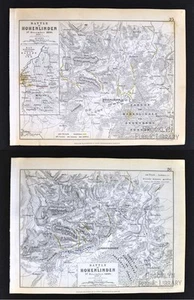


1850 Johnston Military 2 Maps Napoleon Battle of Hohenlinden 1800 Germany Munich
US $49.99
or Best Offer
or 4 interest-free payments of $12.50 available with
Condition:
- Buy It Now1850 Johnston Military 2 Maps Napoleon Battle of Hohenlinden 1800 Germany Munich
Oops! Looks like we're having trouble connecting to our server.
Refresh your browser window to try again.
Shipping:
US $4.99 USPS Ground Advantage®.
Located in: Fairview, Pennsylvania, United States
Delivery:
Estimated between Sat, Jun 7 and Fri, Jun 13 to 94104
Returns:
30 days returns. Seller pays for return shipping.
Payments:
.
4 interest-free payments of $12.50 available with Klarna.
Special financing available. See terms and apply now- for PayPal Credit, opens in a new window or tab
Earn up to 5x points when you use your eBay Mastercard®. Learn moreabout earning points with eBay Mastercard
Shop with confidence
Seller assumes all responsibility for this listing.
eBay item number:405305894117
Item specifics
- region
- france
- mapmaker
- tardieu
- date
- 1833
- publication
- atlas portatif de france
- item
- map
- continent
- europe
- Original/Reproduction
- Antique Original
- Date Range
- 1800-1899
- Type
- Thematic Map
- Format
- Atlas Map
- Cartographer/Publisher
- Alexander K. Johnston
- Year
- 1850
Item description from the seller

Popular categories from this store
Seller feedback (19,863)
- l***4 (121)- Feedback left by buyer.Past 6 monthsVerified purchaseVery nice. Received as seller described on their web site. It was well packaged and at a decent cost. Seller was good at communication and is willing to work with the customer.
- u***g (41)- Feedback left by buyer.Past 6 monthsVerified purchaseGreat seller! Packaged safely and shipped quickly. Great communicator and very knowledgeable. Everything showed up exactly as decribed. Incredible value. 12/10 recommendWest Point WWII Map Operation in Italy Allied Advances from Jan 1944 to Jan 1945 (#365096664387)
- 3***d (376)- Feedback left by buyer.Past monthVerified purchaseItem as described, very reasonable price, fast shipping, carefully packaged. Would buy from this seller again
More to explore :
- Munich Germany 1800-1899 Date Range Antique Europe Maps & Atlases,
- Antique European Maps & Atlases Munich Germany,
- Munich Germany Bavaria Antique Europe Maps & Atlases,
- Munich Germany Antique Original Antique European Maps & Atlases,
- Antique European Maps & Atlases Munich 1800-1899 Date Range,
- Germany 1800-1899 Date Range Antique Europe Topographical Maps,
- Germany 1800-1899 Date Range Antique Europe Atlas Maps,
- Leipzig Germany 1800-1899 Date Range Antique Europe Maps & Atlases,
- Germany Hesse 1800-1899 Date Range Antique Europe Maps & Atlases,
- Germany Brandenburg 1800-1899 Date Range Antique Europe Maps & Atlases
Popular categories from this store
Seller feedback (19,863)
- l***4 (121)- Feedback left by buyer.Past 6 monthsVerified purchaseVery nice. Received as seller described on their web site. It was well packaged and at a decent cost. Seller was good at communication and is willing to work with the customer.
- u***g (41)- Feedback left by buyer.Past 6 monthsVerified purchaseGreat seller! Packaged safely and shipped quickly. Great communicator and very knowledgeable. Everything showed up exactly as decribed. Incredible value. 12/10 recommendWest Point WWII Map Operation in Italy Allied Advances from Jan 1944 to Jan 1945 (#365096664387)
- 3***d (376)- Feedback left by buyer.Past monthVerified purchaseItem as described, very reasonable price, fast shipping, carefully packaged. Would buy from this seller again