
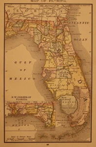
1885 Map - FLORIDA ~ (Small 6x10)-#07
US $16.00US $16.00
Fri, Jul 04, 09:47 AMFri, Jul 04, 09:47 AM
Picture 1 of 3


Gallery
Picture 1 of 3


Have one to sell?
1885 Map - FLORIDA ~ (Small 6x10)-#07
US $16.00
Condition:
“This map is not *new* or in *new* condition. It was removed from an 1885 antique Atlas. See photo ”... Read moreabout condition
Oops! Looks like we're having trouble connecting to our server.
Refresh your browser window to try again.
Shipping:
Free USPS Ground Advantage®.
Located in: Schertz, Texas, United States
Delivery:
Estimated between Fri, Aug 1 and Thu, Aug 7 to 94104
Returns:
30 days returns. Seller pays for return shipping.
Payments:
Special financing available. See terms and apply now- for PayPal Credit, opens in a new window or tab
Earn up to 5x points when you use your eBay Mastercard®. Learn moreabout earning points with eBay Mastercard
Shop with confidence
Seller assumes all responsibility for this listing.
eBay item number:405400539117
Item specifics
- Seller Notes
- Date Range
- 1800-1899
- Type
- State Map
- US State
- Florida, New Mexico
- Format
- Atlas Map
- Year
- 1885
- Original/Reproduction
- Antique Original
- Cartographer/Publisher
- Rand McNally & Co.
- Country/Region
- United States of America
Item description from the seller
Seller Feedback
No feedback yet
More to explore :
- Antique North American Maps & Atlases Florida,
- Florida Topographical Map Antique North America Folding Maps,
- Florida Antique North America River Maps,
- Florida Antique North America Railroad Maps,
- Florida Antique North America Political Maps,
- Florida Antique North America Wall Maps,
- Florida Antique North America Nautical Maps,
- Florida Antique Original Antique North America Folding Maps,
- George Cram Florida Antique North America Maps & Atlases,
- United States of America Florida Antique North America Maps & Atlases