
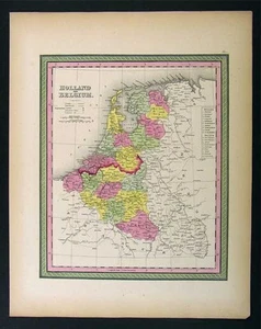

1850 Mitchell Map - Holland Belgium Netherlands Europe

US $28.00
or Best Offer
Was US $35.00 (20% off)
Condition:
Sale ends in: 5h 28m
- Buy It Now1850 Mitchell Map - Holland Belgium Netherlands Europe
Oops! Looks like we're having trouble connecting to our server.
Refresh your browser window to try again.
Shipping:
US $4.99 USPS Ground Advantage®.
Located in: Fairview, Pennsylvania, United States
Delivery:
Estimated between Tue, Jul 8 and Mon, Jul 14 to 94104
Returns:
30 days returns. Seller pays for return shipping.
Payments:
Special financing available. See terms and apply now- for PayPal Credit, opens in a new window or tab
Earn up to 5x points when you use your eBay Mastercard®. Learn moreabout earning points with eBay Mastercard
Shop with confidence
Seller assumes all responsibility for this listing.
eBay item number:405411049084
Item specifics
- Region
- Europe
- item
- map
- mapmaker
- mitchell
- date
- 1850
- country
- netherland belgium
- Original/Reproduction
- Antique Original
- Country/Region
- Belgium, Holland, Luxembourg, Netherlands
- Date Range
- 1800-1899
- City
- Amsterdam
- Type
- Political Map
- Format
- Atlas Map
- Cartographer/Publisher
- Samuel Augustus Mitchell
- Year
- 1850
Item description from the seller

Popular categories from this store
Seller feedback (19,883)
- u***g (41)- Feedback left by buyer.Past 6 monthsVerified purchase--West Point WWII Map Operation in Italy Allied Advances from Jan 1944 to Jan 1945 (#365096664387)
- l***4 (122)- Feedback left by buyer.Past 6 monthsVerified purchase--
- x***u (151)- Feedback left by buyer.Past 6 monthsVerified purchase--
More to explore :
- Netherlands Antique Europe Sheet Maps,
- Belgium Antique Europe Sheet Maps,
- Belgium Antique Europe County Maps,
- Belgium Antique Europe Topographical Maps,
- Belgium Antique Europe Political Maps,
- Belgium Antique Europe Folding Maps,
- Netherlands Antique Europe City Maps,
- Belgium Lithography Antique Europe Sheet Maps,
- Holland Antique Europe City Maps,
- Belgium Antique Original Antique Europe Folding Maps
Popular categories from this store
Seller feedback (19,883)
- u***g (41)- Feedback left by buyer.Past 6 monthsVerified purchase--West Point WWII Map Operation in Italy Allied Advances from Jan 1944 to Jan 1945 (#365096664387)
- l***4 (122)- Feedback left by buyer.Past 6 monthsVerified purchase--
- x***u (151)- Feedback left by buyer.Past 6 monthsVerified purchase--