
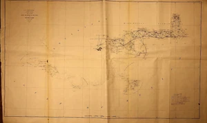
1857 Nautical Chart ~ NEW ORLEANS, LOUISIANA to MOBILE BAY, ALABAMA (XL22x35)#14
US $38.88US $38.88
Sat, Jul 12, 05:03 PMSat, Jul 12, 05:03 PM
Picture 1 of 3


Gallery
Picture 1 of 3


Have one to sell?
1857 Nautical Chart ~ NEW ORLEANS, LOUISIANA to MOBILE BAY, ALABAMA (XL22x35)#14
US $38.88
or Best Offer
Condition:
“This map is not *new* or in *new* condition, it was printed in 1857. See photo for best description. ”... Read moreabout condition
Oops! Looks like we're having trouble connecting to our server.
Refresh your browser window to try again.
Shipping:
Free USPS Ground Advantage®.
Located in: Schertz, Texas, United States
Delivery:
Estimated between Thu, Jul 31 and Wed, Aug 6 to 94104
Returns:
30 days returns. Seller pays for return shipping.
Payments:
.
Special financing available. See terms and apply now- for PayPal Credit, opens in a new window or tab
Earn up to 5x points when you use your eBay Mastercard®. Learn moreabout earning points with eBay Mastercard
Shop with confidence
Seller assumes all responsibility for this listing.
eBay item number:405416970979
Item specifics
- Seller Notes
- Dimensions (inches)
- Approx. 22" x 35" full page
- Date Range
- 1800-1899
- Type
- Nautical Map / Chart
- Paper Type
- Thin - folded paper.
- Year
- 1857
- Country/Region of Origin
- United States
- Military Branch
- US Coast Guard
- Cartographer/Publisher
- A.D. Bache U.S. Coast Survey
- Original/Reproduction
- Antique Original
- Publisher
- U.S. Coast Survey Office
- Shipping
- Free S&H USA - Calculated S&H Worldwide
Item description from the seller
Seller Feedback
No feedback yet
More to explore :
- New Orleans Louisiana Antique North America Maps & Atlases,
- New Orleans Louisiana Antique North America City Maps,
- New Orleans Louisiana Antique North America Atlas Maps,
- New Orleans Louisiana Contemporary Antique North America Maps & Atlases,
- New Orleans Lithography Louisiana Antique North American Maps & Atlases,
- New Orleans New York Antique North America Maps & Atlases,
- New Orleans Antique North America Atlas Maps,
- New Hampshire Antique North America Nautical Maps,
- New Orleans Contemporary Antique North American Maps & Atlases,
- Antique Maritime Navigational Charts