
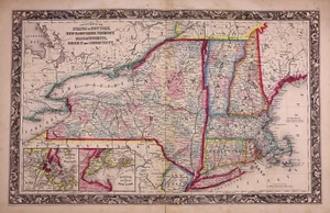
Dated 1860 Map SOUTHERN NEW ENGLAND & NEW YORK STATE - S. A. Mitchell (15x24)#23
US $45.95US $45.95
Fri, May 09, 03:02 PMFri, May 09, 03:02 PM
Picture 1 of 5


Gallery
Picture 1 of 5


Have one to sell?
Dated 1860 Map SOUTHERN NEW ENGLAND & NEW YORK STATE - S. A. Mitchell (15x24)#23

US $45.95
or Best Offer
Was US $48.88 (6% off)
Condition:
“This 160-year-old map is in very good condition, a rare find. It is not *new* or in *new* condition, ”... Read moreabout condition
Ended: May 09, 2025 15:02:52 PDT
Oops! Looks like we're having trouble connecting to our server.
Refresh your browser window to try again.
Shipping:
Free USPS Ground Advantage®.
Located in: Schertz, Texas, United States
Delivery:
Estimated between Wed, Jul 30 and Tue, Aug 5 to 91768
Returns:
30 days returns. Seller pays for return shipping.
Payments:
.
Special financing available. See terms and apply now- for PayPal Credit, opens in a new window or tab
Earn up to 5x points when you use your eBay Mastercard®. Learn moreabout earning points with eBay Mastercard
Shop with confidence
Seller assumes all responsibility for this listing.
eBay item number:405496186377
Item specifics
- Seller Notes
- US State
- Connecticut, Massachusetts, New Hampshire, New York, Rhode Island, Vermont
- Size
- the page is 15x24
- Color
- Beautiful original vibrant, hand tinted colors.
- Cartographer/Publisher
- S. Augustus Mitchell
- City
- New York
- Date Range
- 1860 1st Edition in Series
- Ref
- The title page is only for reference purposes. It is not included
- Type
- State Map
- Format
- Atlas Map
- S&H
- Free S&H USA - Calculated S&H Worldwide
- Year
- 1860
- Original/Reproduction
- Antique Original
- Country/Region
- United States of America
- Age
- over 160 years old
Item description from the seller

Seller feedback (9,610)
- 1***l (18)- Feedback left by buyer.Past 6 monthsVerified purchaseFinally! The "ancestral plat map" arrived and is well worth the long wait!. It is as nice or even nicer than what the seller described. It was packaged adequately, I don't know why it took from 11 April to 5 May to be delivered, but I suspect this was outside the control/responsibility of the seller. I am grateful that this irreplaceable old document was not forever "lost in the mail." Thank you, thank you, thank you!1872 Plat Map ~ FENTON Twp., WHITESIDE Co., ILLINOIS - (15x18)-#10 (#405722860174)
- t***i (1205)- Feedback left by buyer.Past 6 monthsVerified purchasefast shipping...expertly packaged...received as shown/described...great communication...no issues...awesome seller!
- a***z (871)- Feedback left by buyer.Past 6 monthsVerified purchaseOutstanding transaction: Great communication; prompt shipping; secure packaging. Item as shown and described on ebay. Highly recommend MapHatter shop to all ebay buyers!!
More to explore :
- New York New York 1800-1899 Date Range Antique North America Maps & Atlases,
- New York New York 1910-1919 Date Range Antique North America Maps & Atlases,
- New York New York 1700-1799 Date Range Antique North America Maps & Atlases,
- New York New York 1920-1929 Date Range Antique North America Maps & Atlases,
- New York New York 1940-1949 Date Range Antique North America Maps & Atlases,
- New York New York Antique North America City Maps,
- New York New York Antique North America Nautical Maps,
- New York United States of America 1930-1939 Date Range Antique North America Maps & Atlases,
- New York 1920-1929 Date Range Antique North America City Maps,
- New York 1940-1949 Date Range Antique North America City Maps
Seller feedback (9,610)
- 1***l (18)- Feedback left by buyer.Past 6 monthsVerified purchaseFinally! The "ancestral plat map" arrived and is well worth the long wait!. It is as nice or even nicer than what the seller described. It was packaged adequately, I don't know why it took from 11 April to 5 May to be delivered, but I suspect this was outside the control/responsibility of the seller. I am grateful that this irreplaceable old document was not forever "lost in the mail." Thank you, thank you, thank you!1872 Plat Map ~ FENTON Twp., WHITESIDE Co., ILLINOIS - (15x18)-#10 (#405722860174)
- t***i (1205)- Feedback left by buyer.Past 6 monthsVerified purchasefast shipping...expertly packaged...received as shown/described...great communication...no issues...awesome seller!
- a***z (871)- Feedback left by buyer.Past 6 monthsVerified purchaseOutstanding transaction: Great communication; prompt shipping; secure packaging. Item as shown and described on ebay. Highly recommend MapHatter shop to all ebay buyers!!