
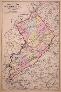
1874 Plat / County Map ~ WARREN County, NEW JERSEY (16x24)-#27
US $63.92US $63.92
Fri, Jul 11, 09:53 AMFri, Jul 11, 09:53 AM
Picture 1 of 2

Gallery
Picture 1 of 2


Have one to sell?
1874 Plat / County Map ~ WARREN County, NEW JERSEY (16x24)-#27
US $63.92
or Best Offer
Was US $68.00 (6% off)
Condition:
“This map is not *new* or in *new* condition. It was removed from an 1874 Warren County, New Jersey ”... Read moreabout condition
Ended: Jul 11, 2025 09:53:33 PDT
Oops! Looks like we're having trouble connecting to our server.
Refresh your browser window to try again.
Shipping:
Free USPS Ground Advantage®.
Located in: San Antonio, Texas, United States
Delivery:
Estimated between Fri, Jul 25 and Thu, Jul 31 to 94104
Returns:
30 days returns. Buyer pays for return shipping. If you use an eBay shipping label, it will be deducted from your refund amount.
Payments:
.
Special financing available. See terms and apply now- for PayPal Credit, opens in a new window or tab
Earn up to 5x points when you use your eBay Mastercard®. Learn moreabout earning points with eBay Mastercard
Shop with confidence
Seller assumes all responsibility for this listing.
eBay item number:405539137135
Item specifics
- Seller Notes
- US State
- New Jersey
- Size
- 16" x 24"
- Color
- Original Hand Tinting
- Cartographer/Publisher
- F. W. Beers & Co.
- Date Range
- 1800-1899
- Type
- Plat Map
- Format
- Atlas Map
- Year
- 1874
- Ward
- Part of First, Second & Third Wards
- Packaging
- All maps are shipped in a secure water-resistant mailing tube
- Original/Reproduction
- Antique Original
- Shipping
- Free S&H USA - Calculated S&H Worldwide
- Country/Region
- United States of America
Item description from the seller
Seller Feedback
No feedback yet
More to explore :
- New Jersey Antique North America County Maps,
- New Jersey County Map Antique North America Atlas Maps,
- Salem New Jersey Antique North America County Maps,
- Antique County Maps,
- New Jersey Vintage Reproduction Antique North America County Maps,
- County Map Antique Wall Maps,
- County Map Antique Atlas Maps,
- County Map Antique Sheet Maps,
- Reproduction Antique County Maps,
- Lithography Antique County Maps