
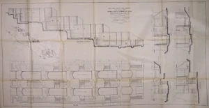
1901 Map ~ FLIGHT of LOCKS at COHOES, NEW YORK (30x56)-#24
US $68.00US $68.00
Fri, Jul 18, 11:10 AMFri, Jul 18, 11:10 AM
Picture 1 of 2

Gallery
Picture 1 of 2


Have one to sell?
1901 Map ~ FLIGHT of LOCKS at COHOES, NEW YORK (30x56)-#24

US $68.00
or Best Offer
Condition:
“This map is not *new* or in *new* condition, it was printed in 1901. See photo for best description.”
Oops! Looks like we're having trouble connecting to our server.
Refresh your browser window to try again.
Shipping:
Free USPS Ground Advantage®.
Located in: Schertz, Texas, United States
Delivery:
Estimated between Sat, Jul 26 and Fri, Aug 1 to 94104
Returns:
30 days returns. Seller pays for return shipping.
Payments:
.
Special financing available. See terms and apply now- for PayPal Credit, opens in a new window or tab
Earn up to 5x points when you use your eBay Mastercard®. Learn moreabout earning points with eBay Mastercard
Shop with confidence
Seller assumes all responsibility for this listing.
eBay item number:405560375240
Item specifics
- Seller Notes
- “This map is not *new* or in *new* condition, it was printed in 1901. See photo for best description.”
- Date Range
- 1900-1909
- Engineering
- Drawing Plans Engineering
- Type
- Topographical Map
- US State
- New York
- Format
- Folding Map
- Year
- 1901
- Original/Reproduction
- Antique Original
- Cartographer/Publisher
- Edward R. Bond Surveyor & Engineer
- NY Canal
- Canal Maps
- Country/Region
- United States of America
Item description from the seller

Seller feedback (9,609)
- 1***l (18)- Feedback left by buyer.Past 6 monthsVerified purchaseFinally! The "ancestral plat map" arrived and is well worth the long wait!. It is as nice or even nicer than what the seller described. It was packaged adequately, I don't know why it took from 11 April to 5 May to be delivered, but I suspect this was outside the control/responsibility of the seller. I am grateful that this irreplaceable old document was not forever "lost in the mail." Thank you, thank you, thank you!1872 Plat Map ~ FENTON Twp., WHITESIDE Co., ILLINOIS - (15x18)-#10 (#405722860174)
- t***i (1204)- Feedback left by buyer.Past 6 monthsVerified purchasefast shipping...expertly packaged...received as shown/described...great communication...no issues...awesome seller!
- a***z (871)- Feedback left by buyer.Past 6 monthsVerified purchaseOutstanding transaction: Great communication; prompt shipping; secure packaging. Item as shown and described on ebay. Highly recommend MapHatter shop to all ebay buyers!!
More to explore :
- New York New York Antique North America City Maps,
- New York New York Antique North America Sheet Maps,
- New York New York Antique North America Topographical Maps,
- New York New York Antique North America Wall Maps,
- New York New York Antique North America Nautical Maps,
- New York New York Antique North America Geological Maps,
- Antique North American Maps & Atlases New York,
- New York Vintage Reproduction New York Antique North America Maps & Atlases,
- New York River Map Antique North America Folding Maps,
- New York City Map Antique North America Atlas Maps
Seller feedback (9,609)
- 1***l (18)- Feedback left by buyer.Past 6 monthsVerified purchaseFinally! The "ancestral plat map" arrived and is well worth the long wait!. It is as nice or even nicer than what the seller described. It was packaged adequately, I don't know why it took from 11 April to 5 May to be delivered, but I suspect this was outside the control/responsibility of the seller. I am grateful that this irreplaceable old document was not forever "lost in the mail." Thank you, thank you, thank you!1872 Plat Map ~ FENTON Twp., WHITESIDE Co., ILLINOIS - (15x18)-#10 (#405722860174)
- t***i (1204)- Feedback left by buyer.Past 6 monthsVerified purchasefast shipping...expertly packaged...received as shown/described...great communication...no issues...awesome seller!
- a***z (871)- Feedback left by buyer.Past 6 monthsVerified purchaseOutstanding transaction: Great communication; prompt shipping; secure packaging. Item as shown and described on ebay. Highly recommend MapHatter shop to all ebay buyers!!