
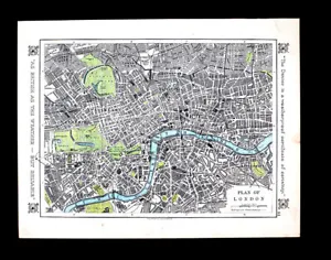


1921 Johnston Map London Plan Thames River Hyde Park Westminister - Dexter Ad

US $28.00
or Best Offer
Was US $35.00 (20% off)
Condition:
“Good, the entire page measures 9 1/2 by 12 inches (24x32cm), see the pics and description below. The ”... Read moreabout condition
Sale ends in: 2d 12h
- Buy It Now1921 Johnston Map London Plan Thames River Hyde Park Westminister - Dexter Ad
Oops! Looks like we're having trouble connecting to our server.
Refresh your browser window to try again.
Shipping:
US $4.99 USPS Ground Advantage®.
Located in: Fairview, Pennsylvania, United States
Delivery:
Estimated between Sat, Jul 5 and Fri, Jul 11 to 94104
Returns:
30 days returns. Seller pays for return shipping.
Payments:
Special financing available. See terms and apply now- for PayPal Credit, opens in a new window or tab
Earn up to 5x points when you use your eBay Mastercard®. Learn moreabout earning points with eBay Mastercard
Shop with confidence
Seller assumes all responsibility for this listing.
eBay item number:405621111939
Item specifics
- Seller Notes
- Cartographer/Publisher
- Alexander K. Johnston
- Original/Reproduction
- Antique Original
- Format
- Atlas Map
- Type
- Political Map
- Year
- 1921
- Date Range
- 1920-1929
- City
- London
- Country/Region
- England
Item description from the seller

Popular categories from this store
Seller feedback (19,881)
- u***g (41)- Feedback left by buyer.Past 6 monthsVerified purchaseGreat seller! Packaged safely and shipped quickly. Great communicator and very knowledgeable. Everything showed up exactly as decribed. Incredible value. 12/10 recommendWest Point WWII Map Operation in Italy Allied Advances from Jan 1944 to Jan 1945 (#365096664387)
- l***4 (122)- Feedback left by buyer.Past 6 monthsVerified purchaseVery nice. Received as seller described on their web site. It was well packaged and at a decent cost. Seller was good at communication and is willing to work with the customer.
- x***u (151)- Feedback left by buyer.Past 6 monthsVerified purchaseMy second order from this seller. As before, the shipping was fast and the map was well packed and protected. Included with the original map was a photocopy of the title page of the book the map came from. Definitely one of my favorite sellers!
More to explore :
- London Antique Europe River Maps,
- River Map Antique Folding Maps,
- River Map Antique Atlas Maps,
- River Map Antique Sheet Maps,
- River Map Antique Wall Maps,
- Antique River Maps,
- London London Antique Europe Atlas Maps,
- Keith Johnston Antique Maps, Atlases & Globes,
- Antique Original River Map Antique Folding Maps,
- Antique Original River Map Antique Sheet Maps
Popular categories from this store
Seller feedback (19,881)
- u***g (41)- Feedback left by buyer.Past 6 monthsVerified purchaseGreat seller! Packaged safely and shipped quickly. Great communicator and very knowledgeable. Everything showed up exactly as decribed. Incredible value. 12/10 recommendWest Point WWII Map Operation in Italy Allied Advances from Jan 1944 to Jan 1945 (#365096664387)
- l***4 (122)- Feedback left by buyer.Past 6 monthsVerified purchaseVery nice. Received as seller described on their web site. It was well packaged and at a decent cost. Seller was good at communication and is willing to work with the customer.
- x***u (151)- Feedback left by buyer.Past 6 monthsVerified purchaseMy second order from this seller. As before, the shipping was fast and the map was well packed and protected. Included with the original map was a photocopy of the title page of the book the map came from. Definitely one of my favorite sellers!